Friday’s weather headlines (x3): Easter update, Rainfall outlook, TC to form off Queensland coast 19th April
14/04/2022 7:00pm
> From the WeatherWatch archives
Here’s what is making the weather headlines today.
EASTER IS MAINLY SETTLED BUT IT’S NOT PERFECT
This is more or less a repeat of the last few days information, but a bit of an update if you will. Easter starts out nice and settled today, please check out today’s forecast for more exact details.
Saturday has a cold front push northwards over the South Island bringing some rain in the west and showers in the south, mainly dry for Canterbury but later in the day or overnight there could be a light shower or two. The North Island is mostly dry with sun but there could be a shower or two about coastal parts in the northeast (East Cape up through to Northland), more so from afternoon. Perhaps some morning fog for the North Island also, mainly about some inland parts then clearing.
Sunday has cloud for eastern regions, perhaps a light shower or two especially the eastern North Island, sunnier and drier out west overall but Coromandel northwards sees showers with breezy easterlies.
Cloud for most of the North Island on Monday with showers for East Cape and also north of the Waikato with easterly winds. The Southwestern corner of the North Island sees some sun though (Taranaki to Wellington). The South Island has mostly sunny weather with any early cloud in the east clearing, South Westland has some cloud with northerly quarter winds.
For more details on your location this Easter please head to RuralWeather.co.nz and use the search function.
Friday 3pm 
Saturday 2pm 
Sunday 3pm 
Monday 3pm
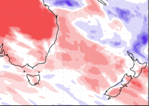
DRIER IN THE EAST COMING UP, NORTHLAND THE WETTEST PLACE NEXT 7 DAYS
The next 7 days for New Zealand is looking drier on average for eastern regions and we can expect average rainfall in the west. Some parts of the West Coast and Northland looks to have wetter than normal weather. The wet weather for Northland is the result of easterlies hanging around there from Sunday through till about Wednesday or Thursday next week.
Precipitation percentage of normal map below running through till Friday 22nd April 2022. Blue is wetter than normal in terms of rainfall expected for this time of year, red is drier than normal.
TROPICAL CYCLONE TO FORM OFF QUEENSLAND COAST 19th APRIL
A tropical cyclone looks to be forming off the coast of Queensland near Cairns around the 19th April. At this stage modelling doesn’t indicate this storm to travel very far then it dissipates around the 24th April to the southeast not far from where it formed. Something we’ll keep an eye on.
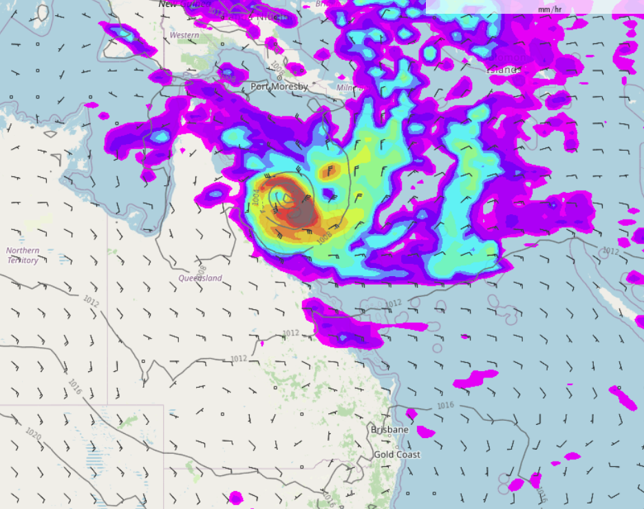
MSLP / Rain map – Tuesday 19th April 3:00pm (NZST) 2022 – WeatherWatch.co.nz 
MSLP / Rain map – Saturday 23rd April 12:00pm (NZST) 2022 – WeatherWatch.co.nz 
MSLP / Rain map – Sunday 24th April 12:00pm (NZST) 2022 – WeatherWatch.co.nz
Latest Video

Cold weekend, frosts return with high pressure, then a low late next week
The subantarctic airflow spreads over NZ today/tonight and into Saturday, dropping temperatures nationwide. Snow flurries are possible today to lower…
Related Articles
Cold weekend, frosts return with high pressure, then a low late next week
The subantarctic airflow spreads over NZ today/tonight and into Saturday, dropping temperatures nationwide. Snow flurries are possible today to lower…

Wintry burst of weather: Snow, squally showers then sunshine & frosts
A polar change (another one!) arrives on Friday for the South Island and goes nationwide on Saturday, leaving NZ under…

Antarctic southerly for parts of NZ Fri & Sat
For the first time this year a southerly from off Antarctica is heading towards the South Island, followed by more…

