Friday’s national forecast – Southerly buster on the way (+ 6 maps)
1/04/2021 3:00pm

> From the WeatherWatch archives
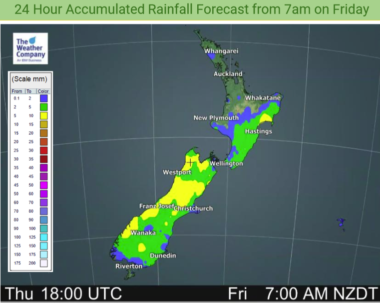
A cold front moves northwards over the South Island today, reaching the lower North Island later this afternoon or evening.
As cold front moves northwards expect rain or showers for most regions. Winds with the southerly change will be strong especially about Canterbury and through Cook Strait.
Temperatures in the late teens or early twenties for most however a bit cooler for the lower South Island and parts of the West Coast. Once the southerly moves through further north, naturally temperatures will drop.
Please refer to your local, hourly, 10 day forecast for more details.
Northland, Auckland, Waikato & Bay Of Plenty
Morning showers, perhaps some rain about Coromandel then clearing away with sunny spells in the afternoon and southwesterly winds. There may be some cloud and a few further showers overnight.
Highs: 21-24
Western North Island (including Central North Island)
Mostly sunny after a cold start inland, light winds tend west to northwest then in the evening southeasterlies freshen bringing a few showers.
Highs: 17-21
Eastern North Island
Mostly sunny, a cold start for inland areas especially Wairarapa. Any morning cloud about Gisborne clears. Light winds tend easterly in the afternoon for Hawkes Bay and Gisborne. Southerlies develop in the evening bringing increasing cloud then showers.
Highs: 20-22
Wellington
Sunny spells, a cold start for inland areas. Late afternoon or evening northwesterlies change strong southerly bringing in showers. Showers clear overnight.
Highs: 18-20
Marlborough & Nelson
Mostly sunny with some developing high cloud. Late afternoon or evening light winds change to the south bringing some rain then clearing overnight.
Highs: 20-22
Canterbury
A dry morning with developing high cloud and warm temperatures, a blustery and strong southerly change arrives around midday bringing rain, easing to showers by evening then clearing away.
Highs: 19-21
West Coast
Showers. Rain about Fiordland spreads into North Westland in the afternoon, clearing by night time. Southwesterlies tend southeast by evening.
Highs: 16-18
Southland & Otago
Rain pushes through in the morning with a southwest change (strong for coastal parts) then sunny spells developing in the afternoon and showers clearing away. It may be warm in the morning for Otago first thing before southwesterlies move in.
Highs: 14-18


Latest Video

Cold fronts continue, wind & rain for some Fri/Sat
Wet weather is moving over the North Island today, while the South Island has drier skies – ahead of another…
Related Articles
Cold fronts continue, wind & rain for some Fri/Sat
Wet weather is moving over the North Island today, while the South Island has drier skies – ahead of another…

Cold fronts vs high pressure
A cold front is moving up NZ today and into Tuesday, but will fall apart as it heads north and…

Wintry change coming for SI and lower NI
Some wet weather, along with a drop in temperatures, will move into the lower South Island later on Sunday and…

