Fiji & Tonga brace for direct impact by potential cyclone, alert for some NZ beaches (+9 Maps)
13/01/2020 10:58pm

> From the WeatherWatch archives
A tropical storm is developing and forecasters expect it to become a tropical cyclone by Wednesday or Thursday with Fiji exposed to a direct hit on Friday, then Tonga this Saturday. New Zealand is unlikely to have a direct hit but the storm may influence beach conditions here creating for dangerous conditions despite the sunny weather here.
FIJI:
The storm will still be developing as it moves through the Fiji area making it a little hard to work out intensity in advance but it’s hoped the storm will likely remain at the lower level of the intensity scale as it crosses land. Therefore rain and blustery winds will be the main concern for all of Fiji. It’s possible that Vanua Levu will be most exposed to a direct hit.
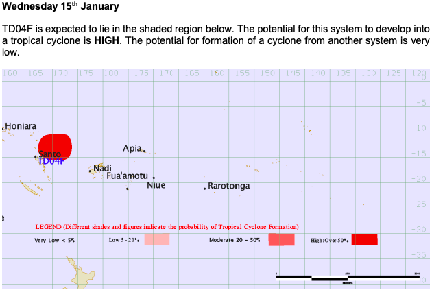
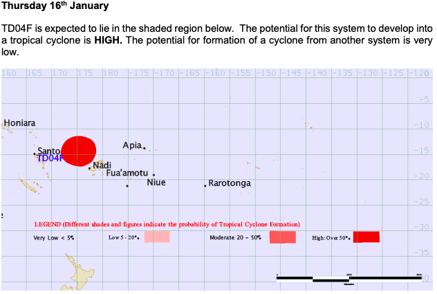
The Fiji Met Service now has high confidence of a tropical cyclone forming this week.
WeatherWatch.co.nz forecasters also expect the storm to be tracking through fairly quickly tracking south to south east. So unsettled weather is mainly on Thursday PM and across Friday. By Saturday it has likely cleared Fiji as it quickly heads to Tonga.
TONGA:
Late on Friday rain will start to set in and north to north east winds will pick up in Tonga. By Saturday the storm will be exiting Fiji and as we said above it will be still developing and deepening. Therefore it may strengthen further into a more serious storm as it approaches Tonga. Torrential rain, gale force winds (damaging potentially) and dangerous seas will cross the small island nation. The centre of the storm, based on modelling, looks to remain just to the west – but will be very close.
Again, the good news is that it is moving through fast so really the 24 hours of Saturday look wet and windy in Tonga but across Sunday winds fade out, skies dry out and the sun returns.
NEW ZEALAND:
Both GFS (American) and ECWMF (European) computer modelling are in agreement with this storm which makes things a lot more straight forward and less confusing.
Both models pick the storm to rapidly develop as it tracks further south towards the NZ area and becomes extra-tropical, probably on Sunday some time. GFS is picking the storm will be closer to NZ than ECWMF (it’s too early to know which will be most accurate). However both place the storm well to the east of East Cape.
DANGEROUS BEACH CONDITIONS IN NZ NEXT WEEK:
The closest this storm will get to NZ (at least based on modelling past few days) shows Sunday night and Monday it will lie roughly the length of the North Island away from Gisborne to our east. This is quite close so definitely worthy of monitoring. While it may not impact our weather too much it may make for dangerous beach conditions in the east of the North Island.
Offshore storms like this have proven deadly in NZ in recent years.
It could be argued offshore storms may even be more dangerous to New Zealanders with sunny weather at our beaches masking the fact the sea may have dangerous random large waves and much more aggressive rips. These increased swells and rips are likely in some eastern beaches of the North Island this coming Sunday, Monday and maybe into next Tuesday too.
While surfers love these set ups, we cannot stress enough how dangerous offshore storms can be for children, or weaker swimmers in the surf – even if the weather at your beach may be stunning, sunny, hot and calm.
TIMELINE:
Noon Friday: Fiji most impacted:
Noon Saturday – Tonga most impacted:
Next Monday: Storm growing bigger as it becomes ex-tropical in the NZ area, generating dangerous swells:
Swell Map for NZ next Monday:
Fiji Met Outlook:


– WeatherWatch.co.nz
Comments
Latest Video

NZ: 8 Day outlook as gales & rain ease, high pressure builds
Damaging wind gusts and heavy rain will continue to affect some parts of the North Island and brushing Marlborough today…
Related Articles
NZ: 8 Day outlook as gales & rain ease, high pressure builds
Damaging wind gusts and heavy rain will continue to affect some parts of the North Island and brushing Marlborough today…

Pockets of hit & miss heavy rain, snow moves northwards
Low pressure continues to slowly move across the upper North Island and for some that will bring the sun out,…

Slow go for northern low & southern cold
For the next few days low pressure will crawl over the upper North Island, driving in rain as far south…


Andrew Hill on 14/01/2020 12:10am
Hi team
From what you can see do we know when the peak of the swell will be for the NE coast of the North Island? It looks like it could be Monday or Tuesday next week, is that your read?
Andrew
WW Forecast Team on 14/01/2020 8:51am
Hey Andrew – keep an eye on the swell maps here with 3 hour increments: http://www.weatherwatch.co.nz/forecast-maps/swell-height
At this stage it looks like Monday PM and Tuesday AM, especially around East Cape, Gisborne and Hawke’s Bay.
Cheers
WW