Even colder air this weekend for the south, rain and snow leans west & south (+2 Maps)
1/08/2019 3:59am

> From the WeatherWatch archives
Another surge of even colder air will move in to the country this weekend, mostly the South Island, with snow in some main centres and bitterly cold daytime highs.
Once again temperatures look to be the biggest feature with a dramatic drop in daytime highs in the lower South Island this weekend and early next week, some inland have afternoon highs around freezing.
LOW TEMPERATURES!
For example, Queenstown’s daytime high for Sunday is currently around 0 degrees with snow showers in the town – fantastic news for the ski fields which need more snow. The overnight low is -4 on Sunday.
Dunedin has a high of only 4 or 5 degrees this Sunday and Monday but the westerly lean to the weather means snow isn’t likely in the city as it may be far too dry.
Invercargill may also only reach 4 or 5 degrees on Sunday which means snow is possible to lower levels around Southland – but with warm soil temperatures at the moment it should melt any snow that falls below 200m fairly quickly.
WHICH MAIN CENTRES HAVE SNOW POSSIBLE?
Snow is forecast to fall, even if briefly, around Lumsden, Gore, Alexandra, Cromwell, Wanaka, Te Anau and even to sea level in Milford Sound and Fiordland National Park this Sunday and/or Monday. This means highway closures or delays look highly likely. Dunedin may get a few flurries but at this stage it looks too dry in Dunedin for snow. Queenstown has a high chance of snow.
But you only have to go about halfway up the South Island and it’s noticeably milder (but still cold!). Hokitika and Christchurch both have highs of around 8 degrees on Sunday, too mild for snow. Once again eastern areas lean dry while the West Coast looks wet.
The North Island is milder still but snow is possible around Central Plateau, Mt Taranaki and along the main ranges. This means Waiouru, Ohakune and National Park may all get snow, even Turangi may get some snow – so again Central North Island highway closures or delays are highly possible this weekend. While Monday will be a cold day for some (Wellington has a high of 10 degrees) it won’t be as wintry as the lower South Island.
Warmer westerlies kick back in next week, especially for the upper half of the South Island and entire North Island. The lower half of the South Island does warm up a little next week but single digit highs look common place, some may just make 10 or 11 for a time mid-week in the deep south.
The coldest air across New Zealand will be this coming Sunday and Monday nationwide.
Next week has a strengthening westerly wind flow across the country.
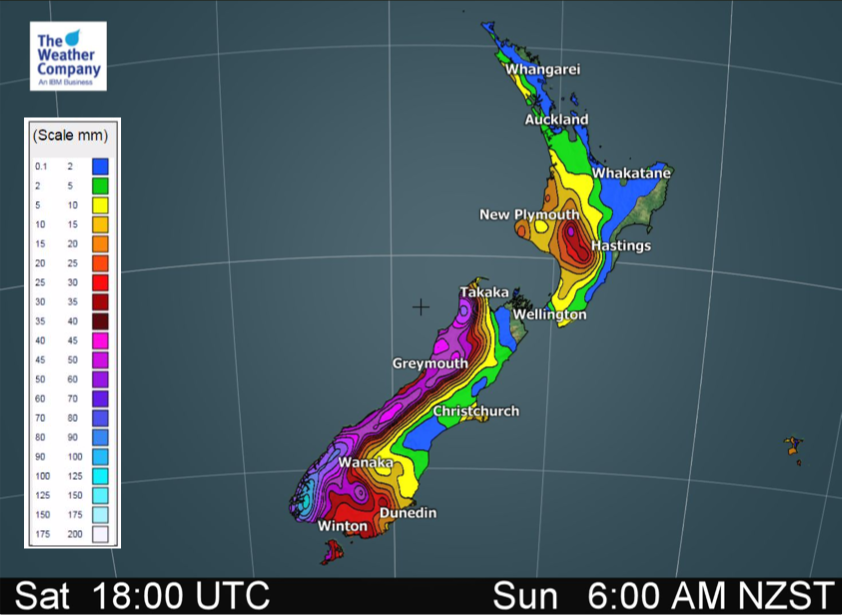
3 DAY SNOW AND RAIN ACCUMULATION MAPS
– WeatherWatch.co.nz
Latest Video

Wintry burst of weather: Snow, squally showers then sunshine & frosts
A polar change (another one!) arrives on Friday for the South Island and goes nationwide on Saturday, leaving NZ under…
Related Articles
Wintry burst of weather: Snow, squally showers then sunshine & frosts
A polar change (another one!) arrives on Friday for the South Island and goes nationwide on Saturday, leaving NZ under…

Antarctic southerly for parts of NZ Fri & Sat
For the first time this year a southerly from off Antarctica is heading towards the South Island, followed by more…

Meteors – Your Eyewitness Reports!
WeatherWatch.co.nz receives meteor reports from all over New Zealand and the globe, 24/7/365. **CASUAL COMMENTS**If you’ve seen something in the…

