Double stormy skies north of NZ – will and how could we be affected?
10/02/2016 7:13pm

> From the WeatherWatch archives
Updated 8:12am — A tropical cyclone is forming between Fiji and Vanuatu today and is still expected to track towards New Zealand area over the next few days – however as we said yesterday computer models are not in agreement about this. So what is the latest data – and based on that – the most likely outlook for NZ?
Firstly – we need to define “what being hit” means. There are two ways: 1) Severe weather 2) Severe beach conditions.
The second scenario has been the main concern from day one, following the increase in drownings when ex-cyclone Victor tracked past New Zealand a couple of weeks ago.
However we are dealing with TWO tropical storms here. While the first, more dramatic one in the models, isn’t showing up so much today, the second one still is for the north of NZ – and both could still impact us with the first one bringing dangerous beach conditions and the second one bringing tropical humid rains to the north — despite no direct hit from either potentially.
Yesterday many New Zealanders, and some government agencies, contacted WeatherWatch.co.nz with great concern over the GFS maps, produced on many sites including WeatherWatch.co.nz, showing a storm hitting New Zealand with severe gales and heavy rain early next week. Our confidence levels of this was 40% on Tuesday, 60% on Wednesday, and again 40% today Thursday. The spike up to 60% yesterday was due to this strong change in GFS. GFS data makes up part of our decision, on top of data we get out of private Australian and US forecasters which uses many other computer models to make a forecast. And Europeans.
Today GFS (US) has backed off significantly from this wild forecast for land – but very little has changed in the rough beach conditions still possible predicted by them.
Swells and waves around Monday and Tuesday look rough and dangerous with 3 and 4 metre waves coming into eastern coastlines of the Upper North Island, like Northland, Coromandel Peninsula, Bay of Plenty, Gisborne and Hawkes Bay.
SECOND LOW
Yesterday we mentioned that was a chance the bigger low could absorb the smaller one – today that is looking less likely based on the past few data updates, meaning the second low may slide in behind the bigger low and push very humid, wet, tropical air over northern New Zealand – and it may set in. Again, we need more time to confirm this.
WHAT ABOUT SEVERE WEATHER ON LAND?
Our confidence levels have dipped today a little further with data last night and this morning for severe weather in New Zealand. As we have said all week, we knew the bigger low would be tracking south towards New Zealand, bringing dangerous seas right into the upper North Island – the big question mark remains: Will this low actually reach New Zealand. Based on all the data today our forecast would be “a direct hit looks less likely from low number 1, but low number 2 still has a question mark over it, hence the general moderate condidence”.
The centre of what we’ve dubbed ‘Low 1″ directly north of NZ will likely come within 800kms of northern New Zealand based on various models today and bring very dangerous beach conditions. Low 2 may move into the upper North Island with heavy rain at the same time – making it feel like one system bringing rough seas and tropical downpours.
There’s a chance we may just get some humidity, wind and downpours rather than severe weather – as we said all this week it will depend on the size of the high to the east of the North Island, as it will directly affect how much wet weather can move into New Zealand and how much gets blocked from tracking southwards towards us.
THERE ARE TWO STORMS
Remember there are TWO tropical lows north of us, the second, weaker, one in the Coral Sea may still end up dragging rain and humid easterlies into the country, in fact it may get pulled down towards Northland as a result of the bigger cyclone potentially missing us. So while severe weather risks are down to 40% today for NZ in our view, we still see this secondary low bringing some heavy rain risks to the country. Yesterday we said there was a good chance these two lows could merge, but latest data instead suggests the bigger storm may help push the smaller one closer towards northern New Zealand.
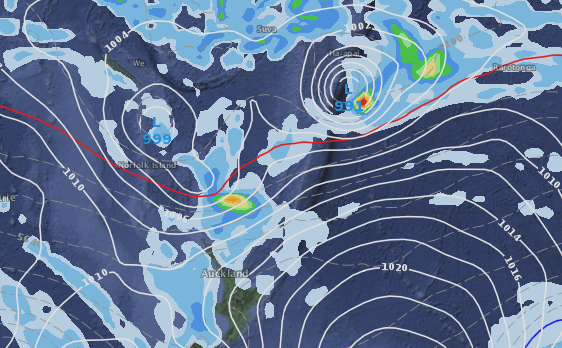
This latest map (below) shows that possible set up, with the more aggressive storm remaining north east of New Zealand while the secondary, but wet and humid, smaller low drags in wet weather towards the upper North Island. The map below is for Monday. This could be a POSITIVE set up for those who need rain, but don’t want a wild cyclone to go with it.
As you can see the computer models are very changeable – we’re doing our best to find the most likely average amongst it all – to avoid the severe flip flopping some computer models give you around these types of storms.
MAY, MIGHT, COULD – “40% confidence”
This far our forecasters use a lot of words like “may”, “might”, “could” etc – this is because there is uncertainty, especially when the main forecast models disagree. Today this is the case – with ECMWF (Europe) suggesting the high to the east of NZ will push back and cause this low to ‘fizzle’ and GFS agrees – however GFS (US Govt) and private data we use from forecasters in Australia and the USA also suggest the smaller low may still bring rain to NZ.

ECMWF map for Monday shows the low further to the north – and the high to the east pushing back against it – stopping it from reaching the North Island effectively.
DANGEROUS SEAS & BEACHES – Updated THURSDAY AM
Regardless of if this cyclone brings severe weather to land on New Zealand, it is very likely to bring dangerous beach conditions – and potentially far worse than ex-cyclone Victor a couple of weeks ago. This could lead to an increase in drownings if people are not aware of the incoming swells, large waves, rips and currents.
Some swell maps are suggesting swells of 5 to 8 metres may come near the upper North Island out at sea, creating damaging waves and flooding tides here. This is based on data today out of MetOcean/Weathermap.co.nz here in New Zealand. If this map is accurate this could lead to some coastal erosion and flooding in the upper North Island’s coastal east. Please be aware – this is just one update and we still need more days to lock in.

Monday’s swell map – via MetOcean/Weathermap.co.nz
WHEN WILL YOU KNOW MORE?
On Friday and the weekend we’ll have a more concrete idea as to the threat to NZ – the fact that GFS (out of US) has backed off a direct hit – after such a dramatic map yesterday that prompted so many of you to contact us, including some government agencies – which prompted us to put all this information out there so you could see that other models weren’t so sure.
We are confident that a cyclone is forming and that it will track south towards New Zealand but unlikely to directly hit New Zealand – we are also fairly confident of very dangerous beach conditions for some northern beaches early next week.
Our overall confidence levels are “low to moderate” that we’ll see severe weather in New Zealand from low 1, and “moderate” from the smaller low 2. We believe both lows bring in a ‘high chance’ of dangerous beach conditions.
MetService forecasters yesterday tweeted they expect two cyclones to form at the end of the week in the South Pacific, but told Fairfax that it was too early to know if New Zealand would be hit, but there was a chance.
WeatherWatch.co.nz says the next couple of days will be crucial at working out most likely scenarios with both of these fairly unpredictable tropical lows.
– Homepage image / The wind and rain map for Monday/Tuesday shows the second smaller low just north of NZ tapping into very humid, sub-tropical, wet air flow for the upper North Island.
– WeatherWatch.co.nz
Comments
Latest Video

NZ: 8 Day outlook as gales & rain ease, high pressure builds
Damaging wind gusts and heavy rain will continue to affect some parts of the North Island and brushing Marlborough today…
Related Articles
NZ: 8 Day outlook as gales & rain ease, high pressure builds
Damaging wind gusts and heavy rain will continue to affect some parts of the North Island and brushing Marlborough today…

Pockets of hit & miss heavy rain, snow moves northwards
Low pressure continues to slowly move across the upper North Island and for some that will bring the sun out,…

Slow go for northern low & southern cold
For the next few days low pressure will crawl over the upper North Island, driving in rain as far south…


pieter van deventer on 11/02/2016 12:22am
Hi Phil,
Any chance that these lows will start interacting (Fujiware Effect – clock wise rotation) and steer the low No. 1 towards NZ?
Thanks
Pieter
matt on 10/02/2016 10:17pm
Hello,
Firstly thanks for the comprehensive and thorough weather update. I am an avid weather follower, so I know a thing or two about the dificulty of cyclone forecasting.
I have a question that may sound stupid especially since I seem to think i know well about weather maps, but i looked everywhere and couldn’t find an answer.
In your vids, your weather map (and the only one I’ve seen) features one long red line and one blue line. Do they signify air temperature? If so, would the blue be for freezing point? What would the red be for ?
Thanks a lot and sorry if the question is silly.
Matt
Dave on 11/02/2016 12:23am
I think you may be referring to the Northern & Southern jetsreams
Cheers Dave
Guest on 10/02/2016 8:46pm
We are extremely vulnerable to the upper winds of the Southern Ocean, which hit us at groud level in Paekakariki, so even if it misses NZ, this low is one I am watching keenly. The ex-TC’s can actually be very cold here, as they drag up air directly from Antarctica directly into us. We’ve never ever been warned for them, despite high winds and not knowing if they’ll be hot or cold. Fingers crossed it’ll be a cold one, as we don’t need high humidity or excessive heat here and have had more than enough heat this summer. Thank you for keeping us informed from an early date Phil.
View more comments