Donna’s ‘wobbling’ positive news for Vanuatu, remains a serious situation this weekend
5/05/2017 9:33am

> From the WeatherWatch archives
UPDATED 9:33pm Friday NZT— Severe Tropical Cyclone Donna remains category 3 status with air pressure of 975hPa at the centre but is wobbling north and south as it tracks around Vanuatu.
Winds may gust up to 250km/h according to the Joint Typhoon Warning Center (US Government, which provides official global data for tropical storms).
Cyclone Donna has been moving along in wave forms, wobbling north and south and the recent jog north westwards looks a bit like someone hurdling, jumping up and over Vanuatu’s more northern islands.
In the past few hours Donna has showed signs of turning southwards.
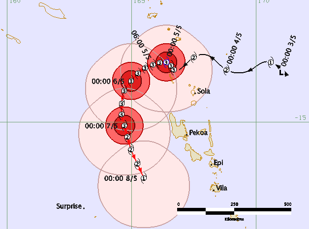
It can be clearly seen here in the Friday PM update from the Fiji Met Service (which is the official forecaster for this particular storm). It’s a positive update again today for Vanuatu as the storm shifts further around the nation. It’s still vital those in Vanuatu remain ready for severe weather though – as you can see in this map below the storm is not tracking in a straight line and it is going to turn south tonight/overnight. It remains somewhat unpredictable.

Donna is going to track southwards west of Vanuatu’s various islands/coastlines over the next three days.
As of Friday evening the centre of Donna was tracking well NW of the main islands but is still fairly close to Vanuatu. Should it continue tracking like this the most severe weather will remain mostly at sea. However it will only take an earlier turn to tracking south to make Vanuatu far more vulnerable to damage and severe weather or even put some populated places in the path of the worst weather. Either way this remains a serious set up for Vanuatu.
Wave heights are over 7 metres and damaging, dangerous, seas will hang around for days around Vanuatu even if the centre tracks further offshore. Coastal damage may still be serious in low lying areas even if the weather isn’t severe on land.
As you can see with any tropical cyclone and such small islands to focus on (Including ours in New Zealand) there is plenty of uncertainty about precise tracking and therefore exactly who may be impacted and when. As we saw recently with Cyclone Cook storms like this can jog west or east further than expected and, over time, a small jog in one direction can have great consequences down the track.
You’ll notice the tracking maps have circles or cones around them (known as the “Cone of Uncertainty”) in the tracking maps – this shows the uncertainty in the days ahead with being 100% precise about where the centre may go…the storm could go anywhere within these zones (see maps below).The Fiji Met Service website overloads during storms – so official information may be hard to get at some times via them.
What lies ahead for New Zealand?
We still see plenty of data that suggests Donna will fall apart early next week as she drifts out of the tropics and directly towards northern New Zealand.
WeatherWatch.co.nz says the latest modelling out today continues to suggest there is still great uncertainty about just where, when and how Donna’s rainy remnants will join forces with a low in the Tasman Sea.
Head forecaster Philip Duncan says New Zealanders don’t need to be concerned at this stage, simply stay up to date with the long range rain maps and news at WeatherWatch.co.nz. “We are confident Donna will drift south towards New Zealand but we are certainly not confident at this early stage that rains heavy enough to cause flooding will lie over land or out to New Zealand’s east coast”. Mr Duncan highlights the fine line between Donna bringing more flooding stresses to the upper North Island or it simply nicking us to the east with just a period of rain – perhaps mainly from the Tasman Sea low.
“Many have asked us what we think might happen and our answer remains it is one to watch but no severe weather forecasts are being locked in for New Zealand at this stage. Donna may miss us or it may slow down and deliver localised heavy falls”.
WeatherWatch.co.nz says the focus over the next few days should be mostly on Vanuatu where severe weather is possible and maybe eastern New Caledonia where severe weather is also possible – perhaps more likely now that Donna is tracked further west.
At this stage New Zealand has a 80% chance of rain next week but as of today only about a 30% chance (in our view) of it causing serious flooding here. One to continue to monitor over the coming days. Donna certainly has a mind of her own.
LATEST TRACKING
All models today have shifted Donna’s track a little further west of Vanuatu for the weekend.
Fiji Met
 JTWC (US Govt)
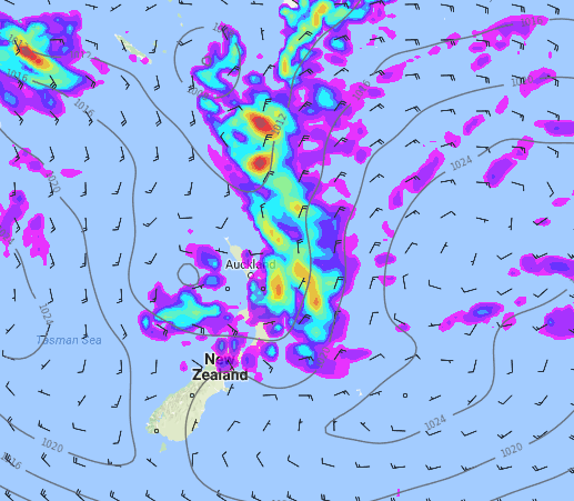 Next Thursday in New Zealand shows a weak low in the Tasman Sea crossing over the upper North Island and linking up with the rainy remnants of Donna – all sandwiched in by two strong highs to the east and west. Latest modelling today suggests Donna’s worst rains may just skirt us offshore, but it’s still far too early to lock in. / Weathermap
– WeatherWatch.co.nz
Comments
Latest Video

Tracking the showers & colder changes
High pressure isn’t over NZ, but is nearby – and it’s affecting our airflows and who gets wet weather and…
Related Articles
Tracking the showers & colder changes
High pressure isn’t over NZ, but is nearby – and it’s affecting our airflows and who gets wet weather and…

Westerlies continue, sub-tropical for some
West to north-west winds blow through the South Island and lower North Island today bring heavy West Coast rain and…

Westerly change this week, unsettled but large dry areas
Westerlies kick back in again this week which will bring a break to those in the east as far as…


Dave on 5/05/2017 1:34am
Great videos Phil well done to you guys
It is looking more & more that Donna could track to the NE of the north island now. If that happens you will be right about the rain thankfully. Lets hope so anyway
They are unpredictable so will be watching with interest. Keep up the great work!
Cheers
Dave