
> From the WeatherWatch archives
WeatherWatch.co.nz has issued its first ever seasonal forecast thanks to IBM and it paints a picture of continuation of our current weather pattern.
*Please note this was originally published November 27*
Put briefly much of the North Island looks both warmer and drier than average while the South Island leans a little cooler and wetter (at least in the west and south of the island). Taranaki and around south Wairarapa may be the only areas a little cooler and wetter in the North Island.
Put Simply:
- North Island leaning drier and warmer than average this summer
- South Island’s West Coast leaning wetter and cooler than average
Rainfall-wise the eastern South Island remains a little bit of a question mark (you’ll notice as asterisk in the summer rainfall map) with average to even slightly above average rainfall forecast – but this is 100% down to the angle of wind flows over the months ahead a slight shift a little more westerly means Canterbury may also be looking at a warmer and drier than normal summer (keep in mind just 10mm of extra rain could help tip Canterbury “wetter than average” – which could come from just afternoon downpours, which can also be very hit and miss).
WeatherWatch.co.nz says with Australia’s drought truly set in it appears the upper North Island of New Zealand is catching some of their high pressure leading to a drying out phase in the North Island over the past few months. These highs are also increasing the sub-tropical (warmer than normal) airflows over NZ.
However an extra stormy Southern Ocean this spring is likely to continue right through December and maybe January too. This, in combination with mild airflows further north, means the South Island may get some heavy rain events on the West Coast and some spillover into Southland and Otago with some cooler air flows out of the Southern Ocean at times.
Remember this isn’t a weather forecast, it’s basically a climate outlook pushing all the forecasts into one map to give an average of temperatures and rainfall. It’s not yet a perfect science so this outlook is designed to help with long term decision making but we know there’s room for improvement so please let us know what we could do better – and clearly at the end of both December and Summer we would very much welcome your feedback on accuracy – and don’t hold back! Our aim is to get better and better in the tricky world of climate outlooks.
WILD CARD EFFECT:
With New Zealand being such a relatively small country compared to the water all around us the one thing that can throw any seasonal and monthly forecasting out is a single air pressure system that can stall over us. If it’s a high it can increase dry and hot weather. If it’s a low – such as a tropical storm – we may get over a months rain in one day in a region that was forecast to be dry. This is what we call the Wild Card Effect and gives those who need rain a silver lining that relief may be coming even if not in the long term outlooks.
WINNERS AND LOSERS:
Always a bit tricky trying to nail this one as it’s often subjective but we do think there are a few clear winners and losers from this outlook:
- POSITIVE: Great news for camp grounds across the North Island and upper and eastern South Island
- POSITIVE: Most main cities look warmer than normal this summer – many may like that
- NEGATIVE: Concerning news for dairy farmers and those who rely on rain water, especially in the upper half of the North Island
- NEGATIVE: Auckland city may well have water shortages again, with a call for people to save water (as the water shortage the city had back in winter still hasn’t been reversed).
- NEGATIVE: Windy weather may linger into January this year for some regions due to an uptick in westerly quarter winds over NZ, especially from the lower South Island southwards.
RAINFALL – DECEMBER:
RAINFALL – DECEMBER:
RAINFALL – SUMMER MONTHS (DEC, JAN, FEB)
RAINFALL – SUMMER MONTHS (DEC, JAN, FEB)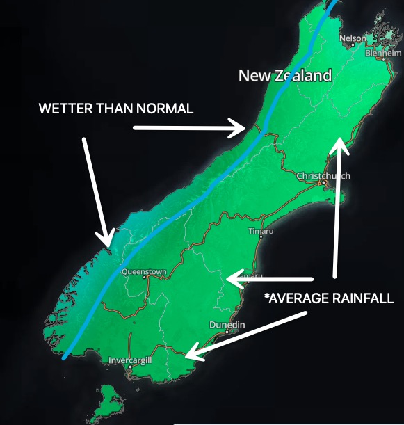
TEMPERATURE TRENDS – DECEMBER
TEMPERATURE TRENDS – DECEMBER
TEMPERATURE TRENDS – SUMMER MONTHS (DEC, JAN, FEB)
TEMPERATURE TRENDS – SUMMER MONTHS (DEC, JAN, FEB)
– WeatherWatch.co.nz – Proud to be an official IBM business partner
*Our outlook is 100% independent of Niwa and MetService – the NZ Government’s commercial tax funded forecasters
Comments
Latest Video

Rain & showers this weekend, colder change next week
Some places will warm up over the next day or so as a nor’wester out of Australia moves across NZ,…
Related Articles
Rain & showers this weekend, colder change next week
Some places will warm up over the next day or so as a nor’wester out of Australia moves across NZ,…

Temperature changes for some regions ahead of heavy West Coast rain
A nor-wester is about to kick in and it’s coming from out of Australia, boosting temperatures in some regions going…

NZ 7 day forecast: Showers, temp changes and heavy West Coast rain
NZ has a fairly messy forecast over the next 7 days, but the main feature will be heavy rain on…


Liz on 28/12/2019 2:21am
Thanks PhilD and team for a fantastic alternative to the new Metservice web page.
Now, if you could just put a link in to current local traffic conditions the site will be perfect!
Liz.
Guest on 11/12/2019 9:11pm
When will it stop raining in Southland. We have had months without a good warm sunny day. Also when will we see the temps get above 20? Even in the forecast we aren’t meant to get any days without rain for the next couple of weeks
Thanks
WW Forecast Team on 11/12/2019 9:28pm
Hi there, you may want to check out our December and summer forecast for Southand. It is leaning a little cooler and a little wetter this year – sorry to report! Should be some great days in the mix too, but perhaps an annoying amount of cloudy or wetter/cooler days too. Full details here: https://www.weatherwatch.co.nz/content/new-december-summer-climate-outlook-new-zealand-8-maps
– Cheers
WW
Allan on 4/12/2019 3:15am
could you make the font bigger please 🙂
Cheers
WW Forecast Team on 4/12/2019 3:38am
100% – wil do next update. Great feedback, thanks!
– WW
View more comments