Day by day: We track the cold blast coming for NZ and when it affects you (+5 Maps)
28/05/2019 8:36pm

> From the WeatherWatch archives
A major change in New Zealand’s weather pattern is about to occur – but we have one day left of warmer than average weather nationwide.
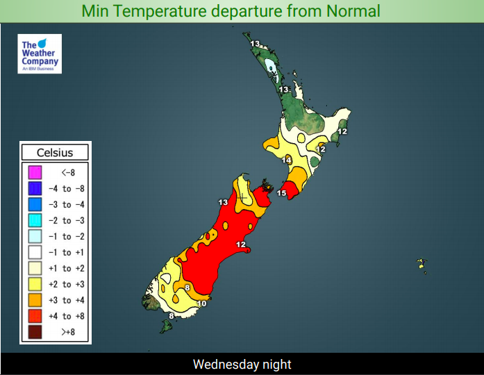
WEDNESDAY: Warmer than average nationwide – both by day and by night by a few degrees, thanks to west to north west winds out of Australia.
THURSDAY: Warmer than average to start with for most places but the main cold southerly change arrives in the lower South Island during the day and will make for a colder than average night across two thirds of the South Island by Thursday night/Friday morning as it slides northwards. The North Island remains warmer than average until Friday.
FRIDAY: On Friday the cold southerly change then moves northwards into the North Island with another colder surge coming in at night and into Saturday morning. For northern NZ this main cold southerly change may not arrive until after midnight and heading into Saturday AM.
SATURDAY: All of New Zealand is under the windier, colder, south to south west flow. Hail, low temperatures, many regions below average temperaturewise by day and squally or wintry showers are all possible.
SUNDAY: Wintry and cold in the east of both islands but improving in the South Island and drying out in the western North Island. Wind strengths ease and lighter winds prevail later, especially inland.
QUEEN’S BIRTHDAY MONDAY: A pleasant slightly warmer change for many regions as westerlies develop. Mostly dry but rain or showers return to the West Coast. Sunnier in the east. Cloudy spells in the North Island’s and should be mostly dry there but perhaps an isolated shower.
TUESDAY: A large low moves in to all of NZ bringing rain nationwide, especially to the western and northern sides of both main islands.


– WeatherWatch.co.nz
Latest Video

Slow moving low to track over northern NZ
A low pressure zone will slowly cross the North Island over the coming days, bringing hit and miss pockets of…
Related Articles
Slow moving low to track over northern NZ
A low pressure zone will slowly cross the North Island over the coming days, bringing hit and miss pockets of…

NI low pressure, SI polar change
Low pressure will move over the upper North Island this week, bringing hit and miss pockets of heavier rain into…

Rain & showers this weekend, colder change next week
Some places will warm up over the next day or so as a nor’wester out of Australia moves across NZ,…

