CYCLONE WINSTON: Fiji’s strongest storm in recorded history now moving in (+8 MAPS)
20/02/2016 4:57am

> From the WeatherWatch archives
UPDATED 5:57pm — Severe Tropical Cyclone Winston remains a monster Category 5 storm as it now moves into Fiji – and it’s breaking records.
Cyclone Winston is the first Category 5 tropical storm in history to hit Fiji & strongest storm on record for the nation.
As of this hour: Severe Category 5 — 917hPa — Moving W at 25km/h — Winds: Sustained 230km/h gusting 325 – 350km/h. Maximum waves: 12 meters (40ft)
As of 5:45pm NZT Cyclone Winston was about 130km/h NE of Suva. The distance between Auckland and Hamilton is 125kms to give you some perspective as to just how close the centre of this storm is to populated areas.
Currently Winston has staggeringly low air pressure, at 917hPa and is still dropping Winds are averaging 230km/h and gusting to 325 to 350km/h or even higher, according to some models.
Our partners at Wunderground have written about Cyclone Winston, saying the tropical storm is now Fiji’s strongest ever cyclone. NZ’s government forecast MetService has today backed this up.
There remains a moderate threat to New Zealand due to the nature of this storm, which is now backtracking towards us – but the focus this weekend is on Fiji and WeatherWatch.co.nz won’t have more information about Winston’s possibly impact on New Zealand until late Sunday or early Monday.
By this Tuesday or Wednesday Cyclone Winston is likely to be in a very similar position to when it was at New Zealand’s closest last Saturday.
Back then the storm was turning north east towards Tonga – this Wednesday it may be tracking south finally, but it’s too soon to lock in whether or not New Zealand will be affected. If today’s modelling is correct, then Winston may still impact the North Island next Friday or Saturday.
One to monitor – and we’ll continue with our frequent updates until the threat to New Zealand has completely passed.
MAPS
RAIN RADAR (5:30pm NZT) / FIJI MET – THE EYE OF WINSTON NOW VERY CLEARLY SEEN 130kms NE of SUVA
Tracking via our new partners at WUNDERGROUND

CLOSE UP OF FIJI WITH TRACKING PLUS INFRARED SAT MAP…FIJI UNDER THE RED SHADING TO THE SW OF THE EYE
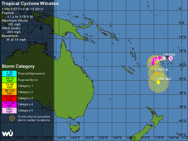 NEXT 5 DAYS – the final position (this coming Wednesday) places Winston back where he was last Sunday / WUNDERGROUND
 CURRENT MAP (4pm hour) — Wind map shows a very disturbing set up – the purple/grey shading in the middle indicates winds SUSTAINED at over 275km/h and gusting over 300km/h. Incredibly destructive.
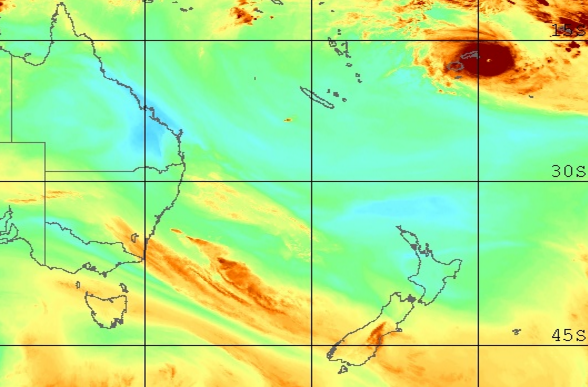 Current Water Vapour map / MTSAT
 Colourised Sat Map / NOAA
 CURRENT (4pm hour) Rain map from today / Weathermap.co.nz
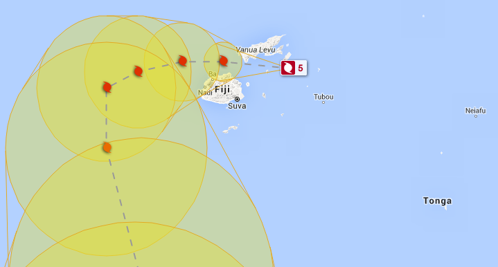
 Current Track Map from FIJI MET
 Latest Tracking Map (and historical track) for Winston / JTWC
Comments
Latest Video

Cold weekend, frosts return with high pressure, then a low late next week
The subantarctic airflow spreads over NZ today/tonight and into Saturday, dropping temperatures nationwide. Snow flurries are possible today to lower…
Related Articles
Cold weekend, frosts return with high pressure, then a low late next week
The subantarctic airflow spreads over NZ today/tonight and into Saturday, dropping temperatures nationwide. Snow flurries are possible today to lower…

Wintry burst of weather: Snow, squally showers then sunshine & frosts
A polar change (another one!) arrives on Friday for the South Island and goes nationwide on Saturday, leaving NZ under…

Antarctic southerly for parts of NZ Fri & Sat
For the first time this year a southerly from off Antarctica is heading towards the South Island, followed by more…


Dyan on 20/02/2016 10:40am
Does anyone know about how the cyclone is affecting Waidoka Bay Surf Dive Resort
My Son and Daughter In Law are there
Thanks
Anna on 20/02/2016 9:51am
we are supposed to be leaving Auckland on a cruise to Fiji on Monday night! Still no update from P&o as to whether this is likely or when they will make that decision 🙁
phil on 20/02/2016 9:39am
I see onen site is predicting that it will bobble around and then strengthen and take another run at Fiji late next week! Guess it shows how unpredictable these things are.
Guestmargaret selby on 20/02/2016 7:10am
Just wondered if any cruise ships are in danger? the carnival ledgend is near Noumea and we have friends on board.
Thankyou
WW Forecast Team on 20/02/2016 7:56am
No idea sorry, but usually the cruise ship website have live cams and tracking so perhaps start there. Normally cruise ships get well out of the way for major storms – and go into ports if in any real danger.
Cheers
WW
Guest on 20/02/2016 5:07am
Great coverage guys
It sure is interesting. It will not be a total surprise if this boy heads west toward Australia.
I look forward to updates.
Cheers Dave
WW Forecast Team on 20/02/2016 6:54am
Hi Dave, thanks a lot. Yes tonight one model picks it will reach Brisbane, another says Gisborne – so we’ll need a couple more days to lock in. One positive is that, for now, most models agree it will weaken significantly next week. One to watch that’s for sure, so we’re now stepping up our daily coverage.
Cheers
WW