Cyclone Lusi – Your many, many, questions answered!
11/03/2014 6:58am

> From the WeatherWatch archives
Cyclone Lusi continues to slowly churn away near Vanuatu – and will likely rapidly intensify over the next three days as it approaches New Zealand from the north.
The weather around this low will be the usual rough weather we get – bit of wind and rain/showers, with some regions staying fairly dry to start with this weekend.
However near the centre of this low winds will likely be hurricane force with intense rain. This is the main area of concern – but this belt of severe weather does not cover the entire system – mostly near the centre.
So until we can accurately pinpoint where the centre will track (and the models are starting to make this clearer now) we can’t yet be too specific about rainfall totals and windspeed maximums.
Generally speaking northern NZ is exposed to heavy rain and strong winds this weekend – but the lower North Island and central New Zealand may also be impacted for at time.
In contrast Southland looks mostly sunny and dry this weekend.
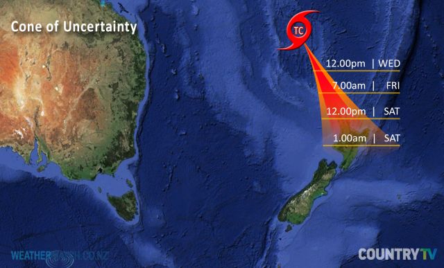
Graphic : Rough timings and locations for Lusi as the storm slips southwards over the next five days.
*Correction – the final time should say 1am SUNDAY. Please note on Weds we will update this graphic, and will aim to get more detailed.
FAQS
How strong will the winds be?
Around the centre of the low we expect sustained winds between gale and hurricane force (basically 65km/h to 120km/h). However the local georgaphy here in NZ can boost winds – or reduce them. 120km/h winds blowing over the Kaimai Ranges, for example, can then speed up to 150km/h +. Other ranges can block the winds – all comes down to the intensity of the low and wind angle as it moves in on Saturday/Sunday.
Where will it be windy?
Most of the North Island will have blustery weather at some point this weekend – not all wiill have gales – but some pockets will likely be exposed to damaging gales. North Island regions west of main ranges are most exposed – so too are all northern regions near the centre of the low. At this stage our main concern for gales will be the eastern Waikato/western Kaimai Ranges, Coromandel Peninsula also parts of Central Plateau, Northland and Auckland.
Will the rain end the dry conditions?
Again it depends on where the centre of the low tracks. Plenty of regions will receive rain from this low – and right now we do expect soaking rains in some of our driest regions. But it may not be until later this week that we can lock in with high confidence those exposed to light rain, heavy rain or missing out altogether. Driest regions in the north of the country will be most exposed to the rain from this low – but it may be too much of a good thing for some areas – rain warnings are likely in our view. This will please many farmers – but may be of concern for those in low lying areas vulnerable to flooding.
When will you be able to lock in more details?
We expect to able to on Wednesday PM and Thursday PM. We also expect MetService to issue more information in the coming days which will help people plan accordingly.
Is it possible severe weather will miss NZ?
As with any tropical low there is always an element of surprise – even for the most experienced meteorologists. There is certainly a chance that weakening of the low combined with a slight direction change could see severe weather risks reduced – but for 9 days that has not been what the various computer models have been predicting. Again we will be able to lock in more around Weds PM / Thurs.
Is this storm going to be big?
Every ex-tropical cyclone is different – even if they look the same as they move in. Bola, Fergus, Drena and Wilma have been the four biggest tropical storms to hit New Zealand since 1988. Sometimes you dont know how significant a tropical storm will be until the day before it arrives/as it’s moving in. Other storms have ‘died’ just 100kms north of Northland. This one doesn’t look overly large – but the models do pick it being intense and deep this weekend over northern NZ, before it falls apart on Monday/Tuesday.
Will everyone be exposed to severe weather?
No – in fact we expect some regions/centres to miss out on severe wind and rain – but those who are exposed do have fairly high risks for severe weather.
Who is most exposed to this storm?
The entire North Island and the upper South Island. However severe weather will likely be focused on the north at first, then may slide further south towards the lower North Island – depending on if the storm holds its strength.
Is it guaranteed to hit us?
No one can say with 100% certainty but right now we have 80 – 90% confidence of a direct hit this weekend – but the storm could weaken rapidly once it moves in. However latest models don’t support that, they show it taking until Monday to fall apart. This is why we are now doing updates two to three times a day now.
Will it still be a tropical cyclone when it reaches NZ?
No, usually cyclones lose their technical “tropical cyclone” title as they transition out of the tropics and over cooler waters near NZ. This transition changes the structure of the cyclone and is why it can be a little tricky tracking them in advance with high precision – especially in a country as narrow as New Zealand . Regardless of the technicality, Lusi’s remnants may still pack similar strengh to Category 1 or 2 tropical storm. Bola, Drena, Fergus and Wilma technically lost their cyclone titles – but 25 years on we still refer to them by their names and call them cyclones.
– WeatherWatch.co.nz
Comments
Latest Video

Cold weekend, frosts return with high pressure, then a low late next week
The subantarctic airflow spreads over NZ today/tonight and into Saturday, dropping temperatures nationwide. Snow flurries are possible today to lower…
Related Articles
Cold weekend, frosts return with high pressure, then a low late next week
The subantarctic airflow spreads over NZ today/tonight and into Saturday, dropping temperatures nationwide. Snow flurries are possible today to lower…

Wintry burst of weather: Snow, squally showers then sunshine & frosts
A polar change (another one!) arrives on Friday for the South Island and goes nationwide on Saturday, leaving NZ under…

Antarctic southerly for parts of NZ Fri & Sat
For the first time this year a southerly from off Antarctica is heading towards the South Island, followed by more…


Guest on 13/03/2014 7:51pm
Hi there,
I am supposed to be driving over the kaimais late friday afternoon from Tauranga to Morrinsville and back, then again on sunday late afternoon and back. Is it safe to do so? From what I am seeing most of the weather will be on Saturday and sunday morning? I’m worried about driving in those winds..
thank you
WW Forecast Team on 13/03/2014 7:55pm
Hi there – please see our lead news story at WW today, it covers all travel questions
– Cheers
WW
Goodwyn on 13/03/2014 6:04am
Hi there! Will the storm still be strong Sunday evening? Never experienced a cyclone before and we fly out of Auckland to LA California 7:30 Sunday night… looks like a lot is still uncertain but curious how long a tropical storm lasts
WW Forecast Team on 13/03/2014 6:23am
Hi there – the good news (at the moment) is that winds look fairly light on Sunday evening in Auckland.
Have a good flight 🙂
– WW
Worried on 12/03/2014 11:21am
Hi there, I am getting married in an outdoor setting on Friday and have many guests coming back on the Saturday for a marquee event….is it going to be safe having people outside in a marquee? And do I need to make alternate plans for my ‘outdoor’ wedding on Friday afternoon?!
WW Forecast Team on 12/03/2014 6:47pm
HI there, unsure where you are based – but Friday looks mostly dry in many places. Saturday sees the rain clouds moving in. To get the best idea please use our wind and rain maps above – as the forecasts do chop and change a bit ahead of tropical lows. All the best for your big day!
– WW
Peace of mind on 13/03/2014 5:23pm
Sorry, we are based in Matamata. Looks like today may be ok? But still concerned about guest’s safety tomorrow.
WW Forecast Team on 13/03/2014 5:51pm
Today will be mostly ok – overnight/tomorrow will be pretty windy for a time with severe gales possible near the ranges.
– WW
View more comments