Cyclone Gita: The latest thinking on rainfall totals across New Zealand (+4 maps)
17/02/2018 10:20pm

> From the WeatherWatch archives
We still have a another day or so to lock this in but here’s the first detailed thinking of rainfall accumulations, by qualified meteorologists WeatherWatch.co.nz partners with on a daily basis.
Gita Highlights as of Sunday:
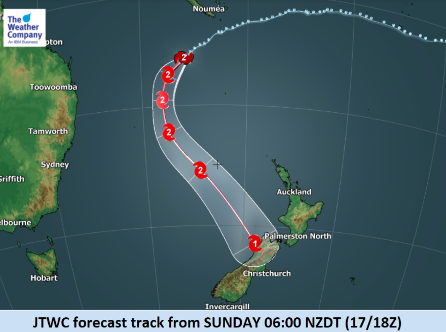
- TC Gita is located to the south of New Caledonia with the maximum sustained wind speed of 111km/h (60 kts)
- It will likely weaken slightly to the 90km/h range across today (50 knots).
- Gita will track southward in the Tasman Sea and thereafter southeastward toward New Zealand.
- Gita is likely to transform to extra-tropical cyclone before approaching New Zealand, interacting with an upper level trough with well marked cold pool. It may still be further south than most cyclones make this change.
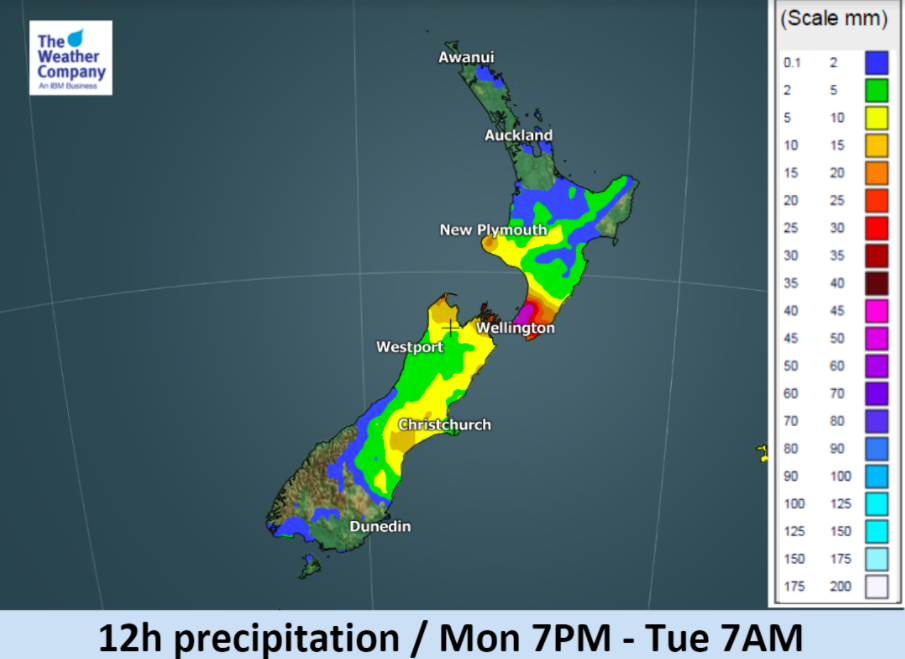
- Before the arrival of Gita itself, the activated front will produce locally heavy rainfall from Monday afternoon to Tuesday morning. The affected area will be southern part of the North Island including Wellington.
- Gita will approach the western coastline of the South Island on Tuesday night, bringing heavy rainfall and violent winds with wind gusts in wide areas in the northern South Island.
- After Tuesday night heavy rainfall is expected to persist mainly in the central South Island, yet the distribution of strong wind and rainfall is uncertain, as models disagree on the further development of the cyclone.
- The cyclone on the west of South Island may partly persist into Thursday morning, producing additional rainfall to the western coast.


– Maps and forecasts by The Weather Company (an IBM business)
– WeatherWatch.co.nz (an IBM business partner)
Comments
Latest Video

Westerlies continue, sub-tropical for some
West to north-west winds blow through the South Island and lower North Island today bring heavy West Coast rain and…
Related Articles
Westerlies continue, sub-tropical for some
West to north-west winds blow through the South Island and lower North Island today bring heavy West Coast rain and…

Westerly change this week, unsettled but large dry areas
Westerlies kick back in again this week which will bring a break to those in the east as far as…

Matariki, the long weekend + the outlook for next week
Wet weather and cloud continues along the eastern side of the country with the heaviest rain now moving into northern…


Karl on 18/02/2018 5:49am
With the storm coming from the south..will it not push Gita up the country further.. and are they going to mix together both storms
WW Forecast Team on 18/02/2018 6:03am
hi Karl – the stormy weather in the Southern Ocean won’t be pushing Gita, high pressure does that work. The storm will split in two over the Southern Alps and this will spread the energy. West Coast of the South Island looks most exposed to damaging and destructive winds at this stage.
– WW