Big high rolls in – Where will the cloudiest areas be? (+3 Maps)
17/09/2019 8:30pm

> From the WeatherWatch archives
High pressure systems can bring incredible sunny weather – but due to our mountains and ranges it can leave other regions cloudy. We have the latest maps tracking where the clouds will most likely be.
We also track any light showers that may be skirting some of our coastal fringes.
High pressure pushes clouds lower so you tend to get low level clouds in coastal areas while inland, especially higher up, is often sunniest.
Here are the latest cloud forecast maps from IBM’s Watson super computer – made exclusively for WeatherWatch.co.nz to display:
WEDNESDAY (Areas in green show showers, areas in blue show snow – down around Fiordland mainly).
THURSDAY (A few showers in Northland and around Fiordland again)
FRIDAY (Cloudiest weather shifts to the eastern side of NZ, there may even be a light shower around Gisborne area)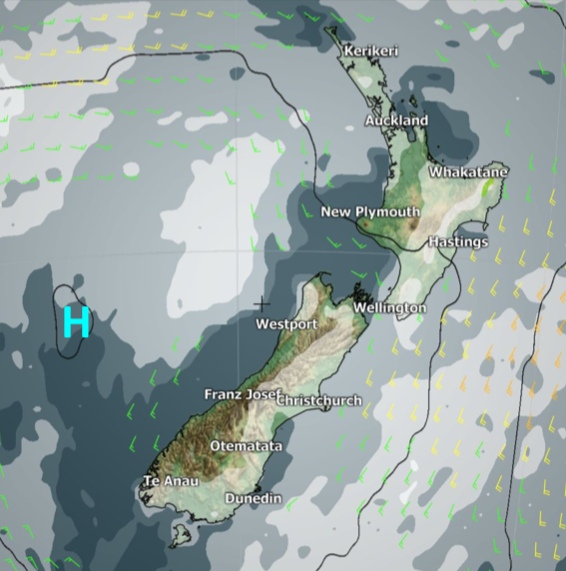
– WeatherWatch.co.nz
Latest Video

Wintry burst of weather: Snow, squally showers then sunshine & frosts
A polar change (another one!) arrives on Friday for the South Island and goes nationwide on Saturday, leaving NZ under…
Related Articles
Wintry burst of weather: Snow, squally showers then sunshine & frosts
A polar change (another one!) arrives on Friday for the South Island and goes nationwide on Saturday, leaving NZ under…

Antarctic southerly for parts of NZ Fri & Sat
For the first time this year a southerly from off Antarctica is heading towards the South Island, followed by more…

Meteors – Your Eyewitness Reports!
WeatherWatch.co.nz receives meteor reports from all over New Zealand and the globe, 24/7/365. **CASUAL COMMENTS**If you’ve seen something in the…

