Australia – Cyclone Debbie may reach Cat 4 (+ Maps)
26/03/2017 4:00am

> From the WeatherWatch archives
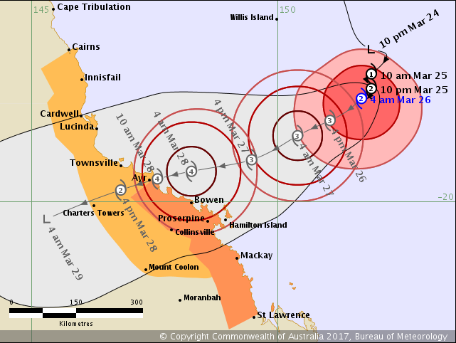
Queenslanders are on high alert as Cyclone Debbie north west of New Zealand continues to intensify and head directly towards the Sunshine State.
The storm is now a Category 2 cyclone (as of 10pm Sunday NZT) and the Bureau of Meteorology in Australia (BoM) is forecasting Debbie to reach a major Category 4 level which could cause significant damage to coastal properties and bring serious flooding inland.
Winds near the centre of this low could be around 240km/h by the time it makes landfall in Australia, most likely on or around this coming Tuesday. Severe weather is likely later today or Monday.
Cyclone Debbie is in the perfect breeding ground for cyclone formation, over the very warm Coral Sea and is being guided in a straight line to Queensland.
The storm may make landfall in a number of areas, some remote/rural other areas to the north of south more populated with towns, cities and tourists.
WeatherWatch.co.nz is now showing Cyclone Debbie’s movements in the animated wind map you’ll find on the homepage of our website (or in the maps section of our free app). This will help you work out where the storm is in comparison to New Zealand and which part of Australia is clearly in the risk zone.
Debbie is the first major cyclone of the entire South Pacific cyclone season which started in November and ends in just four and half weeks. Current conditions around Australia and north of New Zealand are ripe for cyclone formation. While it’s a late and quiet season, March is often the peak of the cyclone season with sea surface conditions now at their warmest.
The leftovers of Cyclone Debbie are unlikely to reach New Zealand, but the humid sub-tropical easterly flow that is guiding it today may drift south and across northern New Zealand in early April bringing more humidity, cloud and isolated drizzle & downpours.
 6am Monday (tomorrow)
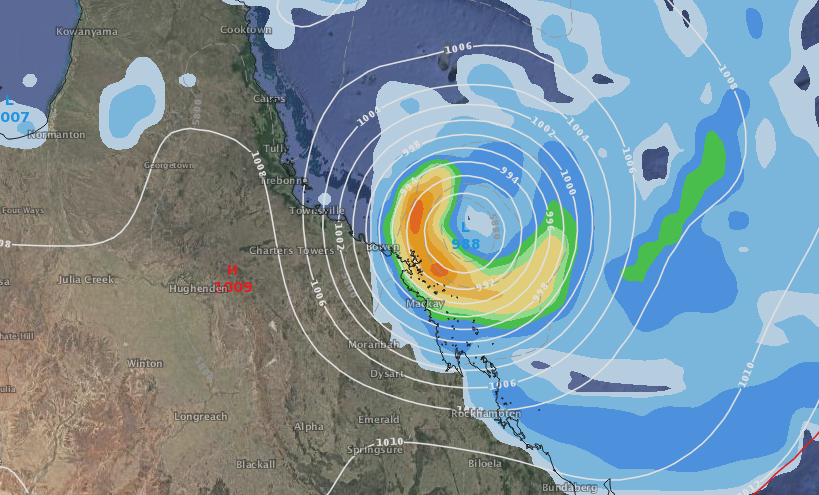
Threat map by BoM as of 11am NZT Sunday
 Current sea surface temperature map / Weathermap
 Sunday AM wind map / Earth
– WeatherWatch.co.nz
Latest Video

NZ: 8 Day outlook as gales & rain ease, high pressure builds
Damaging wind gusts and heavy rain will continue to affect some parts of the North Island and brushing Marlborough today…
Related Articles
NZ: 8 Day outlook as gales & rain ease, high pressure builds
Damaging wind gusts and heavy rain will continue to affect some parts of the North Island and brushing Marlborough today…

Pockets of hit & miss heavy rain, snow moves northwards
Low pressure continues to slowly move across the upper North Island and for some that will bring the sun out,…

Slow go for northern low & southern cold
For the next few days low pressure will crawl over the upper North Island, driving in rain as far south…

