Your official 2018 New Years Eve Forecast! (+Map for this evening)
30/12/2018 3:09pm

> From the WeatherWatch archives
*UPDATED Monday early morning
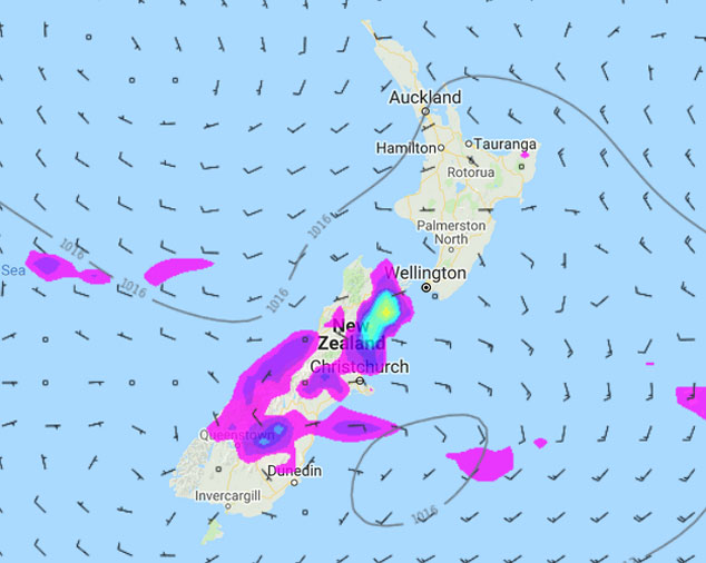
SITUATION: An anticyclone lies to the north of New Zealand today with a light to moderate westerly airflow lying over the North Island. The left over remnants of a front hang over the South Island during today, especially the lower half.
NORTH ISLAND: For Northland conditions are mostly sunny. Auckland has a mix of sun and cloud, perhaps even a shower around midday then cloud breaking away in the evening to finally reveal clearer skies. The Waikato may see a shower or two this morning, cloud doesn’t break away till evening. Some cloud about western Bay Of Plenty, clearing away in the evening, eastern Bay Of Plenty has a mainly sunny day. Winds are light tending to the west this afternoon. The lower western North Island sees mostly cloudy skies with a morning shower or two, cloud breaks to some sun in the afternoon and becoming dry, winds from the west ot northwest. Overnight some cloud may thicken up again for western parts of the North Island.
The east coast of the North Island has a mostly sunny day although expect some high cloud, mainly south of Hawkes Bay. Winds from the northwest, in the afternoon an onshore east to northeast breeze may develop.
SOUTH ISLAND: Rain for South Westland with heavy falls possible this morning, gradually easing from afternoon with dry areas slowly increasing. Mostly cloudy with occasional showers for North Westland south of about Westport, clearing in the evening and cloud may even break away for a time. Winds fairly light from the west or northwest. Nelson and Marlborough are looking to have a mainly dry morning, expect sunny areas and some high cloud with west to northwesterly winds tending onshore after midday. This afternoon isolated showers may develop about hills / ranges especially for Marlborough. These showers may become heavy with thunderstorms then easing and clearing in the evening.
Canterbury sees sunny spells with east to northeasterly winds, cloud may be a little more frequent south of Banks Peninsula bringing the odd isolated shower. Late afternoon / early evening a few heavy isolated showers may develop about inland North Canterbury then clearing at night. From afternoon cloud will start to thicken south of Banks Peninsula then spreading northwards this evening.
Otago sees mostly cloudy skies with a few showers, dry spells developing this afternoon especially nearer the coast, shower activity clears overnight. Winds are mostly light. Southland sees the risk of a shower or two this morning then drying out during the afternoon, fairly cloudy but some sun may break through at times after midday, cloud more likely to break during the evening. Winds are from the southwest.
The top of the South Island and most of the North Island is looking quite warm, high’s in the mid to late twenties for many. Hawkes Bay / Gisborne and eastern parts of Marlborough may see high’s in the thirties. The West Coast of the South Island sees temperatures reach into the high teens, early twenties north of Greymouth. Southland / Otago and Canterbury sees temperatures reaching into the high teens or early twenties, perhaps mid twenties if you are lucky about some inland areas (inland North Canterbury, MacKenzie Country, inland western Otago and inland Southland). Coastal parts of the North Island stay warm into the evening / overnight with low’s in the late teens. Also coastal parts of Nelson / Marlborough. Elsewhere cools down naturally as the sun goes down over the horizon, the coolest spots will likely be Central Otago and most of the inner South Island getting into low double figures overnight.
WHAT THE LATEST MAP FROM WEATHERMAP.CO.NZ IS SHOWING FOR 7PM DECEMBER 31st:

WeatherWatch.co.nz
Homepage image – Allen Pidwell
Comments
Before you add a new comment, take note this story was published on 30 Dec 2018.


Add new comment