Your ANZAC day weather forecast: Ideal for most but a few coastal showers (+3 Maps)
23/04/2019 7:43pm

> From the WeatherWatch archives
Updated Wednesday AM — Most places across New Zealand will have excellent weather for ANZAC but some wet weather is in the forecast which WeatherWatch.co.nz is monitoring.
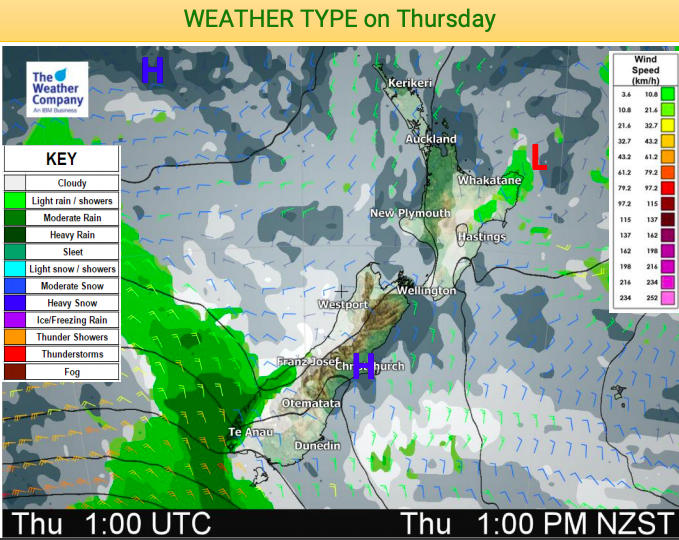
While a large high is expected to push across the country bringing light winds and dry skies there may be some showery weather around the coastal fringes and rain around Fiordland spreading northwards slowly.
The weak low that yesterday (Tuesday) crossed the North Island with a few heavy downpours and isolated thunderstorms will lie east of Gisborne by ANZAC day/Thursday but may still be pushing back light showers (very isolated) anywhere along the eastern coastline of the North Island. In saying that, the island is roughly 85 to 90% dry.
Rain also arrives in Fiordland on Thursday morning but the West Coast should be mostly dry for dawn services – but check your local forecast on Wednesday night as there could be a few showers moving in. Rain becomes heavy in Fiordland later.
AFTERNOON WARMTH
Temperatures for many places in the afternoon will be warm with inland areas of both islands in the late teens or even the low to mid 20s. Some parts of Waikato and Northland may reach 23 degrees which is above normal for this time of year.
Much of the South Island will also be warmer than average on Thursday with highs in the late teens to early 20s.
6AM THURSDAY / DAWN SERVICES FORECAST:
12NOON THURSDAY / LUNCHTIME FORECAST:
– WeatherWatch.co.nz
Comments
Latest Video

Cold weekend, frosts return with high pressure, then a low late next week
The subantarctic airflow spreads over NZ today/tonight and into Saturday, dropping temperatures nationwide. Snow flurries are possible today to lower…
Related Articles
Cold weekend, frosts return with high pressure, then a low late next week
The subantarctic airflow spreads over NZ today/tonight and into Saturday, dropping temperatures nationwide. Snow flurries are possible today to lower…

Wintry burst of weather: Snow, squally showers then sunshine & frosts
A polar change (another one!) arrives on Friday for the South Island and goes nationwide on Saturday, leaving NZ under…

Antarctic southerly for parts of NZ Fri & Sat
For the first time this year a southerly from off Antarctica is heading towards the South Island, followed by more…


Guest on 23/04/2019 3:50am
it seem to be the same pattern for months and some one said they change every three weeks it doesn’t seem so its like ground hog day