Windy and warm Tuesday for large portion of NZ (+4 Maps)
16/11/2020 7:08am

> From the WeatherWatch archives
West to north west winds will gust over 120km/h in some exposed parts of New Zealand on Tuesday, pushing temperatures up above average once again in every part of New Zealand.
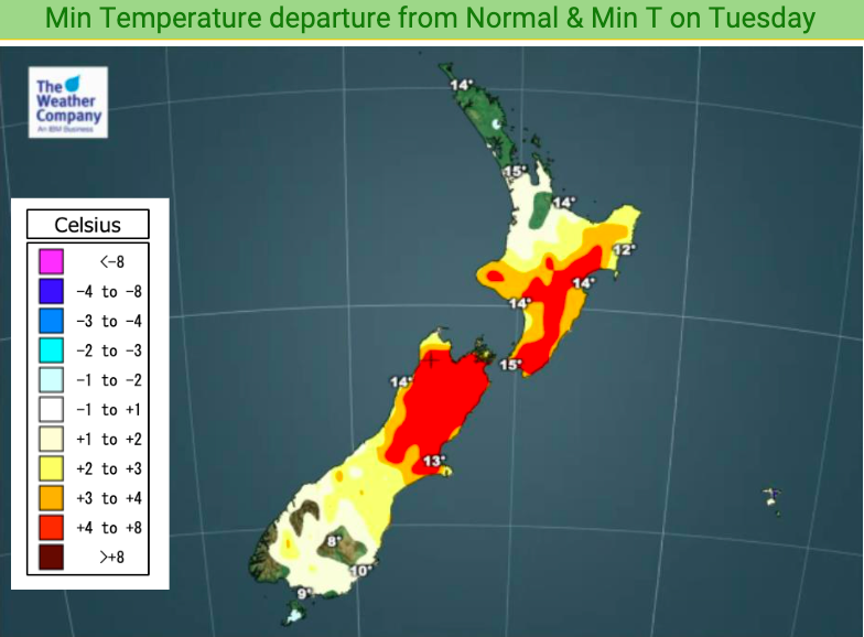
It’s possible parts of Canterbury will reach heatwave criteria on Tuesday after four days with temperatures several degrees above normal. A heatwave is defined as 5 days or more with maximum temperatures 5 degrees or more above normal and Tuesday sees some areas a couple degrees above normal and other parts 4 to 8 degrees above average.
Other parts of the South Island will again be over 8 degrees above normal – before a cool down comes later on Tuesday and into Wednesday.
Winds will pick up in Wellington and Cook Strait across the day (Wellington has had a number of windy days lately) but peak winds will be through the Southern Alps and surrounding ranges across the day.
The windy weather is a typical spring set up with high pressure to the north of NZ and a low just to our south – putting the squash zone of air pressure smack bang over the South Island and lower North Island.
We’ll have more details and maps in our first-at-4am Forecast News update on Tuesday morning.


WeatherWatch.co.nz / RuralWeather.co.nz
Latest Video

Antarctic southerly for parts of NZ Fri & Sat
For the first time this year a southerly from off Antarctica is heading towards the South Island, followed by more…
Related Articles
Antarctic southerly for parts of NZ Fri & Sat
For the first time this year a southerly from off Antarctica is heading towards the South Island, followed by more…

Meteors – Your Eyewitness Reports!
WeatherWatch.co.nz receives meteor reports from all over New Zealand and the globe, 24/7/365. **CASUAL COMMENTS**If you’ve seen something in the…

Snow, rain showers & cold polar southerlies set to return
Friday will be a wintry day across NZ as the next cold front arrives, bringing snow to lower levels of…

