
> From the WeatherWatch archives
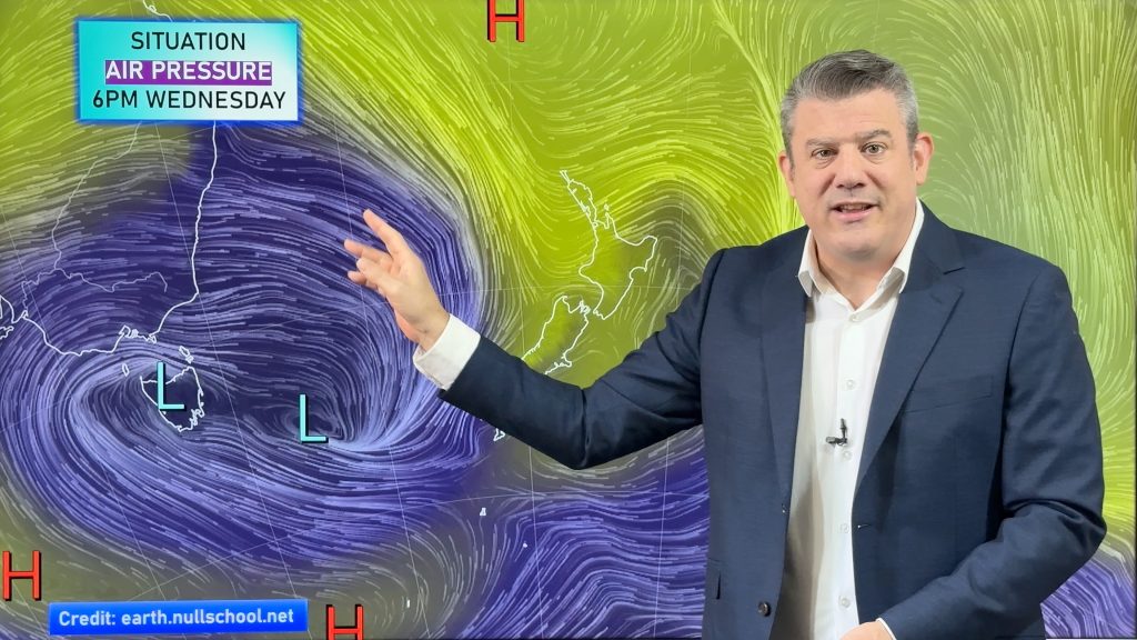
Gale force winds continue to hold over the Far North with gales gusting anywhere from 70km/h to almost 100km/h at Cape Reinga.
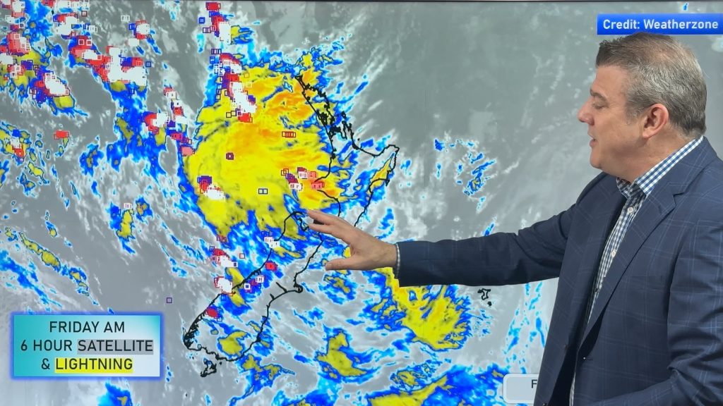
The strong winds are coupled with rain clouds that are literally developing over or near Northland and Auckland – an indication that rough weather is approaching.
Rain continues to move south with heavier rain likely after midnight and during Monday.
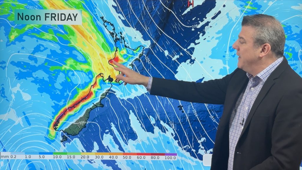
Winds aren’t likely to be a major feature of this system, with rain clouds being the biggest concern and WeatherWatch.co.nz predicts the worst of the weather will be south of Auckland and Hamilton.
The size of the system means heavy rain or showers are likely to affect many regions from tonight through until about Thursday.
The latest Auckland radar shows rain moving over Northland, Auckland, Waikato, Bay of Plenty and Central Plateau.
Comments
Latest Video

Wintry change coming for SI and lower NI
Some wet weather, along with a drop in temperatures, will move into the lower South Island later on Sunday and…
Related Articles
Thunderstorms & downpours as cold front moves through
More heavy downpours and thunderstorms are expected across Friday and into Saturday as a cold front moves through and clears…
Cold front incoming, rain, showers and thunderstorms in the mix
Low pressure in the Tasman Sea is moving into the South Island and will bring more heavy West Coast rain…
More wet weather coming, followed by a colder high pressure zone
A large low pressure zone exiting Tasmania will bring rain, showers and thunderstorms to western and northern NZ going into…


Guest on 24/05/2010 7:21am
weather bomb??? storm in a teacup more like it….again.
karamu49 on 23/05/2010 8:33pm
Good Morning, well as I expected, nothing major this morning here in Mamaku ( Mamaku/Kaimai Ranges, nth of Rotorua. 680 mtrs asl.) wind here is slight with light rain from a NE dir, baro steady at 1020. Phil is right. looks to be a Sth Is affair. Nasty looking sting in that tail on the weather pic. Cheers
karamu49 on 23/05/2010 11:06am
Hi From Mamaku, I’m gonna stake my money on Alan’s prediction. Having seen many cyclones and storms coming down from the tropics they do tend to veer away to the east and I’m pretty much gonna say thats what will happen with this one. Pretty calm here in the ranges and had some rain, enuf to wet the ground. The barometer hasnt even moved still sitting (all day) at around 1016. What do you reckon Phil. this “blow”, gonna head over to the east. Cheers
WW Forecast Team on 23/05/2010 11:22am
No we don’t expect much wind from this system over Auckland and Waikato during Monday… however strong to gale nor’westers may kick in on Tuesday afternoon… but thats probably more of an Auckland event that Mamaku.
Won’t be much of a storm for you or Auckland on Monday – although rainfall figures maybe high tomorrow afternoon down your way.
WeatherWatch forecasts now show this is increasingly looking like a South island event for Monday/Tuesday.
But on Tuesday it becomes a northern and west coast event as well…..very messy – will have a very clear understanding of this storm tomorrow morning once it’s developed a lot more.
Doesn’t surprise me about the barometer not moving – afterall, there’s very little wind out there. It’s most likely to start dropping in 12 to 24 hours.
– Phil
Hamo on 23/05/2010 10:16am
We have had light but steady rain here Just South Of Hamilton at Rukuhia since around 3.30pm we have no wind however not even a breeze, are things likely to pump up wind wise for us? We want the rain but not the gales force winds thank you very much lol
Guest on 23/05/2010 10:03am
here in kaukapakapa it has just rained for a little bit more drizzel then rain and the wind has dropped again as it was a biit windy just few minutes ago.
Diana on 23/05/2010 9:47am
No.. its not too bad.. overcast dark skies, but nothing has arrived in the Manawatu.. Its believed it will pass over and other cities will get it.. we should get just mild rain by all accounts and perhaps some gentle breezes with odd strong gusts.
The waiting game is on.
Alan Charman on 23/05/2010 8:13am
I’m going to predict “fizzer” on the incoming storm. It doesn’t appear to be developing the type of weather worthy of “bomb” status and my money is on it being no worse than any other winter storm.
Guest on 23/05/2010 8:54am
Yea 10/4 im kinda agreeing with Alan on this one . I mean i think we are gonna get some heavy rain an possibly prolonged periods of rain for some parts of the country but im starting to get the feeling that the storm that was is not as bad as it was earlier during the week . You look at the satelite images its a pretty big cloud mass A blocking high would certainly change the outcome of this weather event i feel . Phil you have all the weather data at your finger tips what do you reckon now ? cheers Dan
WW Forecast Team on 23/05/2010 9:08am
Hi all,
It’s a tricky one. I think as far as heavily populated places go, this storm will miss a lot of them. Chch may actually end up being affected by prolonged rain.
The system will be split tomorrow – deep low in the Tasman and a weaker one NE of NZ. Auckland & Hamilton are in the middle, which should mean over 1.5 million people probably will see very little of the "serious" stuff.
It’s hard to tell from the satellite maps because the low is only just developing… clouds and rain bands are yet to appear out of ‘thin air’ overnight and during tomorrow…by Tuesday the storm should be twice the size of the system we’ll have when we wake up tomorrow.
I wouldn’t call it a fizzer…it’s definitely big and grumpy… but still a question mark as to which regions will see the absolute worst…but based on the data at my hands now, I’d say it’s likely to be south of Waikato.
Still rain warnings in force for Northland and Auckland regions though…and by the looks of the current rain radar they are appropriate. Big rain bands developing over those regions. Definitely one to watch.
But my pick is for more action further south, less populated areas, so probably less news coverage and damage.
Hope that isn’t too on the fence… but as with any large developing system it’s hard to pinpoint exactly where it’s going to go…a bit like watching a whirlpool move down a rushing river.
View more comments