
> From the WeatherWatch archives
The low in the eastern Tasman Sea, near New Zealand, doesn’t look very spectacular on the satellite map. So why is that?
Basically the low is fed by moist air that it pulls down from its north eastern quarter.
With the low so large and wide, all the moisture is being pulled down on the eastern side of New Zealand – and the air is mostly dry when it passes over the Southern Alps and gets pulled back towards the centre.
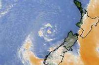 The centre of the low has been fairly unimpressive on satellite images, almost impossible to pick at times by the untrained eye.
However the low is likely to generate more moisture today with some heavy showers move into the west coast of the North Island this afternoon and into tomorrow.
Image: The eye of the severe low hardly even showing up directly west of the Nelson region. Image / Weather.com
Comments
Latest Video

Some polar airflows but more high pressure to affect NZ’s weather
Showers are in the forecast over the next several days, we track where and when they occur – but there…
Related Articles
Some polar airflows but more high pressure to affect NZ’s weather
Showers are in the forecast over the next several days, we track where and when they occur – but there…

Tracking the showers & colder changes
High pressure isn’t over NZ, but is nearby – and it’s affecting our airflows and who gets wet weather and…

Westerlies continue, sub-tropical for some
West to north-west winds blow through the South Island and lower North Island today bring heavy West Coast rain and…


Guest on 24/05/2010 9:26pm
Hi Phil,
Any update for the thunderstorms in auckland today – what time would they be passing through?
Cheers
WW Forecast Team on 24/05/2010 9:48pm
We have low to moderate confidence of isolated thunderstorms. Certainly a high chance of heavy, squally, showers though.
– WeatherWatch team
Guest on 25/05/2010 9:40am
“Certainly a high chance of heavy, squally, showers though.”
Yep – the “heavy, squally, showers” are here…
We just had more rain (by 3 millimeters) over the past 40 minutes than we have had over the past 24 hours. Very squally as well with big fat pregnant rain drops… the kind of rain drops which don’t so much ‘patter’ the roof, but rather splat into it sounding more like rotten seedless plums.
🙂
Guest on 25/05/2010 10:11am
moderate confidence of isolated thunderstorms
I these are lurking around now as well…
🙂
sw on 24/05/2010 7:19pm
These lows dont really have an “eye” as such,yes it has a centre,sometimes cloud or clear skies with lesser wind but its the convection often circling it is the concern on windward coasts.
WW Forecast Team on 24/05/2010 7:34pm
You’re quite right – it’s really only cyclones/hurricanes that have an eye.
– WW
Guest on 25/05/2010 9:45am
Don’t forget Tornadoes!
🙂
Guest on 25/05/2010 10:17am
>>> Don’t forget Tornadoes!
Speaking of Tornadoes – Taranaki so far has been lucky…
Let’s hope it stays that way.
😉