Where the heaviest rain is going to fall over the next few days (+4 Maps)
11/02/2018 10:53pm

> From the WeatherWatch archives
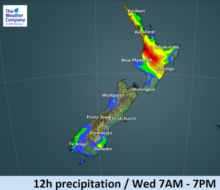
Heavy rainfall has been observed in both islands over the weekend, mainly over the central and western North Island and northern South Island. A narrow front lies draped over the eastern Upper North Island for Monday but will become more consolidated on Tuesday as it drifts back west.
The qualified meteorological team at The Weather Company now work daily with WeatherWatch.co.nz to provide exclusive weather news updates, specific local forecasts and nationwide weather maps. We hope you find this new content helpful.
Weather Highlights for the next few days:
- Localised but heavy rainfall is expected to persist today over some parts of the Upper North Island, specifically around the ranges of Bay of Plenty – both west and east.
- Isolated thunderstorms may occur but will be not frequent.
- Tuesday the front over the North Island will be more consolidated but may also drift over the Tasman Sea.
- Locally heavier rainfall totals than forecast are possible especially in hilly areas.
- Many areas further south will be drier.
- Humidity remains high, up to 100%, in the upper North Island at times over the next couple of days.
- Overnight lows will not drop below the low 20s for some parts of the northern North Island.
- The South Island and lower half of the North Island looks significantly drier.


– WeatherWatch.co.nz – an official business partner of IBM/The Weather Company
Latest Video

Frosts, late week rain & another cold weekend coming
High pressure will cross NZ over the next few days meaning more cold nights/mornings with frosts, but a nor’wester will…
Related Articles
Frosts, late week rain & another cold weekend coming
High pressure will cross NZ over the next few days meaning more cold nights/mornings with frosts, but a nor’wester will…

NZ: Cold & windy, then calm & frosty
Downpours, some squally with the chance of thunderstorms and even small tornadoes are possible for parts of NZ over Friday…

WeatherWatch App launches real-time local lightning tracker
A bolt out of the blue! WeatherWatch has launched a live, real-time lightning tracker, enabling Kiwis to gain access to data provided by the…

