Weather headlines (x3) for Wednesday: Very frosty, Showers about to clear eastern NI, Mainly dry coming up
21/06/2022 7:00pm
> From the WeatherWatch archives
Here’s what is making the weather headlines today.
VERY FROSTY
Thanks to high pressure we are certainly very frosty. This risk continues tomorrow morning and again on Friday morning. Saturday morning we start to get out of the frost risk zone.


LAST DAY FOR SHOWERS EASTERN NORTH ISLAND
Showers for Hawkes Bay and Gisborne finally clear away overnight. Tomorrow showers start to spring up for Northland and some western parts of the South Island, especially later in the day.

MSLP / Rain map – Wednesday 3pm 
MSLP / Rain map – Thursday Midnight 
MSLP / Rain map – Thursday 9pm
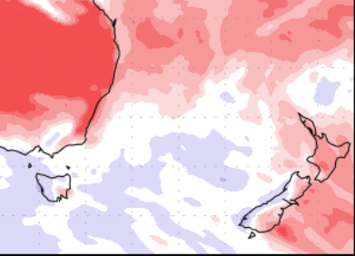
OUTLOOK MAINLY DRY APART FROM WEST COAST
The weather coming up for the next 7 days looks to be drier than normal for New Zealand as we can see in the map below, red is drier than normal, blue is wetter than normal. The darker the colour the more intense the dry or wet weather is.
Just the West Coast picks up some wetter than normal weather (although not overly so, just a tad wetter than normal), mainly due to a front moving through on Saturday and perhaps another around the end of the month.
Latest Video

More eastern rain, but a drier long weekend coming
Rain continues today along the eastern South Island and lower North Island, coming in from the east with heavy falls….
Related Articles
More eastern rain, but a drier long weekend coming
Rain continues today along the eastern South Island and lower North Island, coming in from the east with heavy falls….

More heavy rain, snow – but large dry areas, especially as we go into the long weekend
Heavy rain will continue for parts of Canterbury and Marlborough over the next day or two and it will gradually…

Large low brings rain, downpours & some snow – gets colder as the week progresses
Low pressure will cross the upper North Island in the days ahead and that set-up actually pushes more heavy rain…

