Weather headlines (x3) for Tuesday: Heavy rain in the west later on, Strong winds overnight, Rain outlook
30/05/2022 7:00pm

> From the WeatherWatch archives
Here’s what is making the weather headlines today.
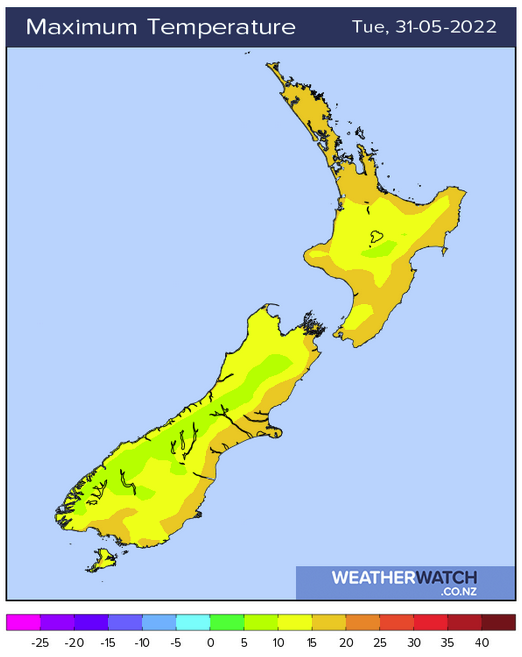
WARM IN THE EAST, HEAVY RAIN IN THE WEST LATER ON
New Zealand is between systems today with yesterdays front now well out to out east and another front lining us up in the Tasman Sea. Expect warm temperatures for eastern regions and the upper North Island getting into the late teens or early twenties.
Rain later this evening / overnight for western regions becomes heavy as a front closes in, there may be thunderstorms also. More on today’s thunderstorm risk here.
STRONG WINDS LATER ON / OVERNIGHT
The front heading into western regions later this evening has strong northeasterly winds ahead of it. Western parts of the country can expect strengthening northeasterly winds this evening, winds may rise to gale about some coastal parts. Overnight expect strong north to ortheasterly winds about Nelson / Marlborough and Bay Of Plenty for a time before switching over the eastern coastal areas, winds start to ease in the east around dawn on Wednesday.
Wednesday itself sees strong northwesterly winds through central parts of the country, winds through Cook Strait will likely be gale force.
Wind map – Tuesday 9pm 
Wind map – Wednesday 12am 
Wind map – Wednesday 3am 
Wind map – Wednesday 6am 
Wind map – Wednesday 3pm
RAIN OUTLOOK NEXT 7 DAYS
Through to Tuesday 7th June most regions are looking to see average to above average rainfall. The eastern South Island though is looking dry though thanks to most of out weather coming in from the west during this period.
The eastern South Island doesn’t stay completely dry, it does get showers or some rain on Friday for a time as the airflow changes southwest then drying out on Saturday.
Latest Video

Frosts, late week rain & another cold weekend coming
High pressure will cross NZ over the next few days meaning more cold nights/mornings with frosts, but a nor’wester will…
Related Articles
Frosts, late week rain & another cold weekend coming
High pressure will cross NZ over the next few days meaning more cold nights/mornings with frosts, but a nor’wester will…

NZ: Cold & windy, then calm & frosty
Downpours, some squally with the chance of thunderstorms and even small tornadoes are possible for parts of NZ over Friday…

WeatherWatch App launches real-time local lightning tracker
A bolt out of the blue! WeatherWatch has launched a live, real-time lightning tracker, enabling Kiwis to gain access to data provided by the…

