Weather headlines (x3) for Thursday: Heavy rain moves into the far north, Snow flurries in the south, Frost risk
13/07/2022 7:00pm

> From the WeatherWatch archives
Here’s what is making the weather headlines today.
HEAVY RAIN MOVES INTO THE FAR NORTH
A low pressure system heading towards the North Island from the north starts to bring rain into Northland this afternoon with heavy falls. Rain with a chance of heavy falls spreads to other parts of the upper North Island this evening then overnight reaching across into eastern regions.
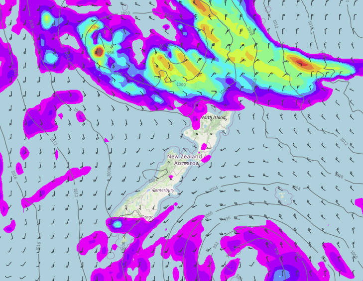
MSLP / Rain map – Thursday 3:00pm 
MSLP / Rain map – Friday 3:00am
SNOW FLURRIES TO 500M IN THE SOUTH
South to southwesterly winds continue to push showers into Southland and Otago (especially southern parts of the region) today and on Friday, expect snow flurries to about 500m.

POTENTIAL FOR FROSTS COMING UP
If skies are clear enough and winds light enough over the next few nights then frosty conditions will develop, as can be seen in the frost risk maps below. Check out this page here for updated maps as we move forward.


Comments
Before you add a new comment, take note this story was published on 13 Jul 2022.
Latest Video

NZ VIDEO: Severe weather going into the weekend. Next week: Westerlies continue
Heavy rain and northerly gales are moving across NZ going into the weekend as a large low from the Tasman…
Related Articles
NZ VIDEO: Severe weather going into the weekend. Next week: Westerlies continue
Heavy rain and northerly gales are moving across NZ going into the weekend as a large low from the Tasman…

VIDEO: Low pressure, cold fronts, main feature next two weeks
There are several low pressure zones and cold fronts coming into NZ, with westerly driven weather dominating our weather pattern…

VIDEO: Burst of wind and rain for NZ as low pressure dominates
Air pressure around New Zealand will continue to drop in the days ahead as low pressure systems affect our weather…


Add new comment