Weather headlines (x3) for Thursday. Colder air in the south is now moving northwards
5/01/2022 7:26pm
> From the WeatherWatch archives
We bring you the top 3 weather news headlines for today.
COLDER CHANGE MOVES INTO SOUTH ISLAND, HEADS NORTH
Temperatures are today well down in the south, in fact almost 20 degrees cooler today than the daytime highs on Monday, like in parts of Southland.
Dunedin has a high of +12 in some suburbs and Christchurch only 15C with again more cloud and drizzly areas possibe.
Wellington is also much cooler than previous days with a high of +18C today and +17C tomorrow.
Hawke’s Bay and Gisborne have highs in the low 20’s next few days but bounces back closer to 30C by Sunday.
The top of NZ, places like Coromandel Peninsula, Auckland and Bay of Islands are slightly impacted by the cooler change. Daytime highs will drop a few to several degrees on Friday compared to earlier this week, but mid 20s again by Sunday.
You can find temperature maps here:

APART FROM A FEW SHOWERS, NZ REMAINS MOSTLY DRY NEXT 7 DAYS
There are a few showers, especially in the upper South Island’s interior and some parts of the North Island too – but apart from that the forecast is mostly dry across NZ for the next 7 days ahead due to very dominant high pressure zones exiting from the Aussie region and drifting over us.
The map below (thanks to the US Government) shows the rainfall departure from normal over the next 7 days, with red/pink showing drier than usual, white areas normal rainfall for January’s second week historically, and blue showing where the rain and downpours and wetter weather is.

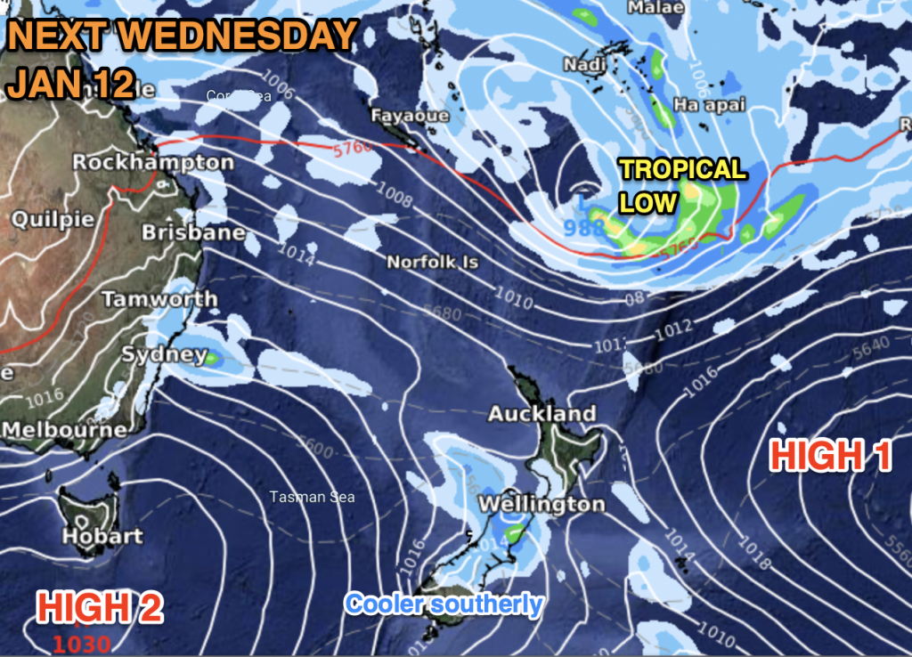
TROPICAL ENERGY CONTINUES TO BUILD – HIGH PRESSURE IN NZ AREA BLOCKING IT (For Now)
Low pressure is still likely to dominate the tropics next week – but NZ is looking quite protected from it due to dominant high pressure.
A high (High 1) will be exiting NZ to the east, encouraging an easterly flow in the sub-tropics and this could help guide low pressure more towards NZ. However, another high (High 2) is coming in from the Tasmania area. Tropical lows can’t move through high pressure, they either fall apart trying, or they get guided along sideways – sometimes they stall and can sit in the same part of the tropics for 2 weeks without being able to drop south.
So it’s a waiting game – the low is likely to form, but high pressure looks likely to continue keeping NZ dry.
In our ClimateWatch report for Jan 1 we mentioned how rain may possibly to impact northern NZ from a tropical low, but there is a fine line between this wet weather and the very dry weather under high pressure in the NZ area. If the high pressure is more powerful all that wet weather can be shunted just a little further out to sea – keeping NZ drier than forecast. One to continue to monitor, our next update will be on Friday morning.
Latest Video

Slow go for northern low & southern cold
For the next few days low pressure will crawl over the upper North Island, driving in rain as far south…
Related Articles
Slow go for northern low & southern cold
For the next few days low pressure will crawl over the upper North Island, driving in rain as far south…

Slow moving low to track over northern NZ
A low pressure zone will slowly cross the North Island over the coming days, bringing hit and miss pockets of…

NI low pressure, SI polar change
Low pressure will move over the upper North Island this week, bringing hit and miss pockets of heavier rain into…

