Weather headlines (x3) for Monday: Frosty this morning, Nice weather in the east, Heavy rain / Strong winds on Tuesday
31/07/2022 7:00pm
> From the WeatherWatch archives
Here’s what is making the weather headlines today.
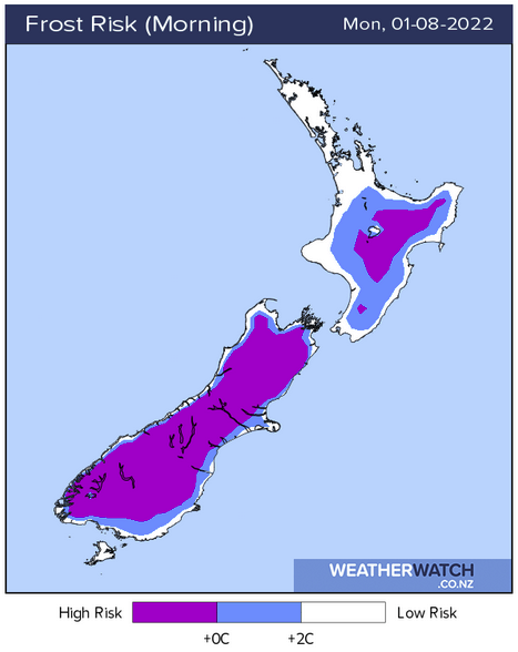
FROSTY START THIS MORNING
Widespread frosts are likely for the South Island this morning and also many inland parts of the North Island.
Inland South Island areas would have likely ranged between -5 to as low as -10 in some spots first thing this morning. The Mackenzie Country would have likely been the coldest.
NICE DAY IN THE EAST
Eastern regions will likely have a nice day today, a bit of a change from last week. Some high cloud may work into the South Island’s east coast though.
Temperatures getting into early double figures from Southland up through to Canterbury in the east, Marlborough and up the east coast of the North Island sees highs getting into the mid teens. Temperatures getting into the mid teens for the upper North Island today also.
Tuesday on wards sees higher temperatures for eastern regions, in the mid to late teens.


HEAVY RAIN AND STRONG WINDS ON TUESDAY
A front moves over the South Island on Tuesday bringing heavy rain to the West Coast as it moves northwards, reaching Buller in the evening, thunderstorms may occur also.
Northwesterly winds will be strong over the South Island and lower North Island, gales are possible in the east for Canterbury / Marlborough and will be very likely through Cook Strait.
For any watches and warnings put out by Metservice, please visit this page here.


Latest Video

NZ: 8 Day outlook as gales & rain ease, high pressure builds
Damaging wind gusts and heavy rain will continue to affect some parts of the North Island and brushing Marlborough today…
Related Articles
NZ: 8 Day outlook as gales & rain ease, high pressure builds
Damaging wind gusts and heavy rain will continue to affect some parts of the North Island and brushing Marlborough today…

Pockets of hit & miss heavy rain, snow moves northwards
Low pressure continues to slowly move across the upper North Island and for some that will bring the sun out,…

Slow go for northern low & southern cold
For the next few days low pressure will crawl over the upper North Island, driving in rain as far south…

