Weather headlines (x3) for Friday: Weather warnings today, Nice weather in the north, Snow moves in Sunday – South Island
4/08/2022 7:00pm

> From the WeatherWatch archives
Here’s what is making the weather headlines today.
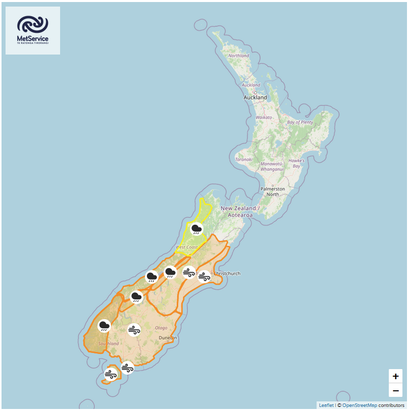
RAIN AND WIND WARNINGS ARE IN FOR TODAY
Northerly winds strengthen over the South Island today with gales about some eastern parts of the South Island from this afternoon, especially inland.
Rain becomes heavy about Fiordland this afternoon then spreads into North Westland this evening.
Check out today’s rain and wind warnings from Metservice here.
NORTH ISLAND HAS GOOD WEATHER TODAY AND TOMORROW
To be more specific all of the North Island has good weather today after any morning fog clears, some high cloud moves in from the west this afternoon. Temperatures are warm this afternoon reaching into the late teens.
Tomorrow the eastern and upper North Island has the best weather while in the southwest (Taranaki to Wellington) cloud thickens, showers then rain develops in the evening.

MSLP / Rain map – Friday 3:00pm 

MSLP / Rain map – Saturday 3:00pm 
COLD AIR STILL MOVES INTO THE SOUTH ISLAND ON SUNDAY
Cold air is still forecast to move into the South Island on Sunday with snow likely to fall about the ranges. Lowering to 300m in the south around midday, 300m for Canterbury late afternoon then 400 to 300m about Kaikoura / southern Marlborough overnight.
Overnight snow lowers to 200m south of Canterbury and may get as low as 100m for coastal Otago although overnight precipitation levels for coastal Otago drop away so any snow flurries to 100m will be minimal.
Cold air continues to hang about the eastern South Island on Monday through to Wednesday with further snow flurries in the ranges ranging anywhere between 400 and perhaps as low as 200m.

Latest Video

Wintry weather coming: Snow, rain, wind & sunshine
A cold front is moving into NZ from Friday to Sunday with low pressure developing west of NZ and then…
Related Articles

Polar airflow + northern low = pockets of heavy rain & snow
A colder change is coming – and so too is a large low which will develop and grow over northern…
Wintry weather coming: Snow, rain, wind & sunshine
A cold front is moving into NZ from Friday to Sunday with low pressure developing west of NZ and then…

ClimateWatch: JULY outlook & what El Niño means for NZ
El Niño is officially here and still getting stronger in the months ahead, but it’s harder to notice its effects…

