Weak southerly change making for pockets of cooler weather today, Autumn is arriving (+2 Maps)
9/03/2019 6:00pm

> From the WeatherWatch archives
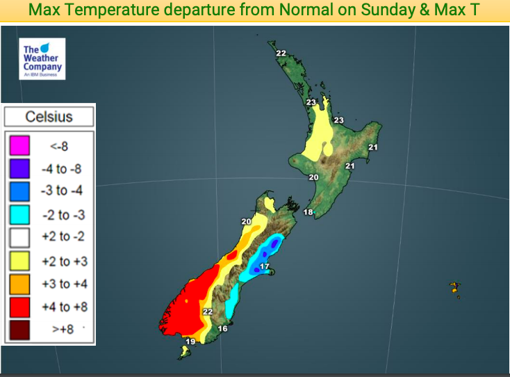
Eastern parts of the country will be cooler today with daytime highs below normal for some, especially parts of Canterbury and coastal Otago where day time highs may be a few to several degrees below normal.
On top of the cooler air flow it will be cloudier with showers, especially the further north you go up the eastern coast.
However many areas won’t be below or above normal temperature-wise, they will be about where they should be for the second week March. Warmest places look to be the West Coast and upper inland North Island today, while tonight the upper North Island will be a little cooler than normal. Eastern areas of the South Island not only have a cooler than normal day today, but also tonight is below normal.
In true Autumnal style places like Canterbury are bouncing around temperature-wise with a cooler day today but low to mid 20s by Tuesday, mid to late 20s by Wednesday and back to the teens on Thursday. We can expect more and more temperature fluctuations in the weeks ahead as we continue to see Autumn arriving.

– WeatherWatch.co.nz
Latest Video

Cold weekend, frosts return with high pressure, then a low late next week
The subantarctic airflow spreads over NZ today/tonight and into Saturday, dropping temperatures nationwide. Snow flurries are possible today to lower…
Related Articles
Cold weekend, frosts return with high pressure, then a low late next week
The subantarctic airflow spreads over NZ today/tonight and into Saturday, dropping temperatures nationwide. Snow flurries are possible today to lower…

Wintry burst of weather: Snow, squally showers then sunshine & frosts
A polar change (another one!) arrives on Friday for the South Island and goes nationwide on Saturday, leaving NZ under…

Antarctic southerly for parts of NZ Fri & Sat
For the first time this year a southerly from off Antarctica is heading towards the South Island, followed by more…

