Snow continues to move north as bitterly cold gales start to develop (+10 Maps)
8/08/2021 8:45am

> From the WeatherWatch archives
8:45pm update — The coldest air will move in overnight tonight and across Monday with gale to severe gale southerlies kicking in overnight tonight, especially around Cook Strait and coastal parts of the North Island.
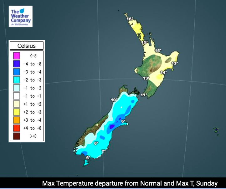
While most New Zealanders can already feel the temperature drop, the upper North Island actually leaned a little milder for Sunday, but by tomorrow it will be below normal as far as maximum temperatures are concerned, with only the exception of the West Coast which will have normal daytime highs for this time of year (protected by the Southern Alps).
WeatherWatch.co.nz received reports and photos/video of snow falling in Ashburton, Darfield, Timaru, Springfield, Arthur’s Pass, Geraldine, Oxford, Temuka, Fairlie but missed Christchurch despite some sleeting falls going that low. Based on the latest data it doesn’t look as though snow flurries will settle at sea level or be significant, also likely mixed in with rain.
The North Island is expected to get snow on the ranges and mountain tops of Waikato and Coromandel Peninsula, also the Gisborne Ranges.
Hail is likely in Wellington and isolated light snow flurries or a rain/snow mix may make it in to some higher up suburbs – but won’t likely settle if it does fall. Amounts will be very low if at all.
Weather in bullet points
- A front and low pressure system are passing over NZ through Sunday PM and across Monday.
- It will bring widespread rain, showers and/or snow with gusty winds.
- Scattered thunderstorms and/or heavy downpours are possible in some areas of the North Island such as Auckland/Northland down to Taranaki and the lower North Island today (mainly afternoon).
- Gusty winds near 100 km/h are likely in coastal areas of the North Island around Cook Strait in early Monday, with gusts 120 to 140km/h in the more extreme exposed areas of the lower North Island and Marlborough Sounds.
- Snow totals are forecast up to 50 cm in mountainous areas of the South Island through Monday morning.
- Snow of 1 cm or less may mix in with rain showers, even in lower areas of the South Island as well as the North Island.
- Sea level snow is possible along the eastern South Island, but is marginal and not likely to settle long or accumulate too much.
- Highest chance for low level snow will be in the hours of darkness overnight tonight.
- Max temps will run much colder than average from Sunday PM to Tuesday AM in many regions and even in the North Island highs run single digit on Monday for most.
- This is a short lived event peaking from Noon Sunday to Midnight Monday — milder weather is expected from Tuesday and Wednesday across the country.
- The next cold front with rain is expected to approach the South Island from Wednesday with heavy rain likely on the West Coast and totals adding up to 100 mm over Wednesday and Thursday.


Need Wind Chill data in your hyper-local area? Or wind gusts? Visit www.RuralWeather.co.nz – NZ’s largest weather data website. It’s all about being local!
Comments
Before you add a new comment, take note this story was published on 8 Aug 2021.
Latest Video

NZ VIDEO: Severe weather going into the weekend. Next week: Westerlies continue
Heavy rain and northerly gales are moving across NZ going into the weekend as a large low from the Tasman…
Related Articles
NZ VIDEO: Severe weather going into the weekend. Next week: Westerlies continue
Heavy rain and northerly gales are moving across NZ going into the weekend as a large low from the Tasman…

VIDEO: Low pressure, cold fronts, main feature next two weeks
There are several low pressure zones and cold fronts coming into NZ, with westerly driven weather dominating our weather pattern…

VIDEO: Burst of wind and rain for NZ as low pressure dominates
Air pressure around New Zealand will continue to drop in the days ahead as low pressure systems affect our weather…


Add new comment