Update on the snow, rain & wind and cold weather for Fri/Sat (+7 Maps)
11/10/2018 9:40pm

> From the WeatherWatch archives
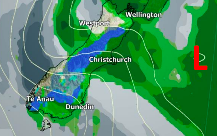
A significant cold blast is heading northwards bringing winter weather conditions to the lower South Island with snow flurries down to about 250m and wintry rain showers. Snow has fallen in Queenstown and rain is falling across a large portion of Canterbury, a region which is drier than average right now.
Heavy showers have also been crossing the North Island, affecting many regions which are drier than average. More showers are coming today and on Saturday morning, some heavy.
Snow moves into the North Island later today with some flurries down to just 400m but these flurries will not likely settle, but may impact SH2 from Wellington to Wairarapa, SH5 from Napier to Taupo and SH1 the Desert Road for a time tonight.
The southerly change is today moving up the South Island and will later today and tonight/early Saturday move over the North Island.
Milder winds return for many places by Sunday and Monday but frosts are possible inland and higher up in both islands this weekend.


– WeatherWatch.co.nz
Latest Video

Cold weekend, frosts return with high pressure, then a low late next week
The subantarctic airflow spreads over NZ today/tonight and into Saturday, dropping temperatures nationwide. Snow flurries are possible today to lower…
Related Articles
Cold weekend, frosts return with high pressure, then a low late next week
The subantarctic airflow spreads over NZ today/tonight and into Saturday, dropping temperatures nationwide. Snow flurries are possible today to lower…

Wintry burst of weather: Snow, squally showers then sunshine & frosts
A polar change (another one!) arrives on Friday for the South Island and goes nationwide on Saturday, leaving NZ under…

Antarctic southerly for parts of NZ Fri & Sat
For the first time this year a southerly from off Antarctica is heading towards the South Island, followed by more…

