Typhoon Hagibis makes direct aim for Tokyo as it makes landfall in Japan
12/10/2019 11:19am

> From the WeatherWatch archives
- Wind: Destructive winds with an average wind speed of almost 100km/h are expected over some parts of Kinki & Hokuriku regions and the Japan Sea side of northern Japan from Saturday night to Sunday dawn.
- Wave: Up to 10m of significant wave height (SWH) is expected over the coasts of Kyushu and Shikoku until Saturday morning, and over the Pacific side of the Tohoku region from Sunday dawn to noon. Also, up to 6m of SWH is expected over even the Pacific side of Hokkaido on Sunday afternoon.
- Rain: Torrential rain is expected from Saturday morning (which is the timing before the destructive wind blows) over between the Pacific side of the Tohoku region & the Kii Peninsula (i.e. in various regions). In addition, Record heavy rain will continue for a long time in some parts of the plain in the Kanto region.
- Tide: This period is also spring tide, in addition to the effects of the typhoon moving from from sea to land, seasonal high sea surface temperatures can cause storm tides over Tokyo Bay, Sagami Bay and Suruga Bay on Saturday (Expected central pressure when the TY approaching these bays: 935 – 945 hPa, i.e. very low value).
LATEST on #TyphoonHagibis:
– Air pressure 935hPa
– Maximum wave height 13M
– Landfall around Kanto region from Saturday night
– #Hagibis expected to be equal to Cat 2 Hurricane at landfall
– Centre of storm to cross over/very near #Tokyo
– Rainfall rates of 75mm/hr possible pic.twitter.com/49p2kcB1c4— WeatherWatch.co.nz (@WeatherWatchNZ) October 11, 2019
#TyphoonHagibis model update. A very serious situation continues to unfold.
– Map 1: Now (3pm NZDT, 11am JST)
– Map 2: 9PM Sat NZDT, 5PM Sat JST
– Map 3: Midnight NZDT, 8PM Sat JST#Hagibis #Japan #Tokyo #Weather pic.twitter.com/bqItIINCHW— WeatherWatch.co.nz (@WeatherWatchNZ) October 12, 2019
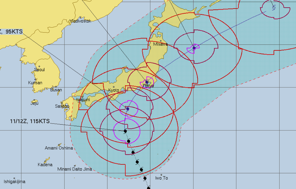
Latest: #TyphoonHagibis is moving into #Japan now.
The latest tracking continues to show the centre of this destructive storm tracking directly over #Tokyo.
Full local details attached: pic.twitter.com/gBF6bqiWud
— WeatherWatch.co.nz (@WeatherWatchNZ) October 12, 2019
#BREAKINGNEWS: #TyphoonHagibis has made landfall in #Japan and is now crossing land. #Tokyo in the firing line. Full details here: https://t.co/vpdIZh37gH
Current Maps: pic.twitter.com/NctrzTQzpB
— WeatherWatch.co.nz (@WeatherWatchNZ) October 12, 2019
Latest Video

NZ: 8 Day outlook as gales & rain ease, high pressure builds
Damaging wind gusts and heavy rain will continue to affect some parts of the North Island and brushing Marlborough today…
Related Articles
NZ: 8 Day outlook as gales & rain ease, high pressure builds
Damaging wind gusts and heavy rain will continue to affect some parts of the North Island and brushing Marlborough today…

Pockets of hit & miss heavy rain, snow moves northwards
Low pressure continues to slowly move across the upper North Island and for some that will bring the sun out,…

Slow go for northern low & southern cold
For the next few days low pressure will crawl over the upper North Island, driving in rain as far south…

