
> From the WeatherWatch archives
Two lows are tonight spinning towards both islands bringing severe weather, reports WeatherWatch.co.nz.
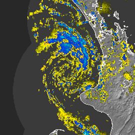
“This low moving into the North Island looks like the perfect storm” says head weather analyst Philip Duncan. “It has a clear centre to it and incredible looking rain clouds spiralling around it”.
The low is fast moving towards the Waikato and Auckland regions with torrential rain. “Downpours will be torrential and may cause surface and flash flooding from Waikato to Auckland”.
 “There’s also the risk the low may generate a water spout or isolated tornado” says Mr Duncan.
WeatherWatch.co.nz says gusts have been reaching 140km/h at the Manukau Heads and as the low moves in some isolated damage is possible.
Meanwhile in the South Island another low is hammering the east coast with heavy rain.
Image: Perfect looking low moving into Waikato region. Image/MetService.
However WeatherWatch.co.nz says the rain is clearing from the north east this evening and has already cleared Christchurch and Banks Peninsula and is clearing southwards towards Timaru and Oamaru.
Rain warnings remain in force for the area tonight with MetService making no mention of rain clearing and instead saying heavy rain will remain until Wednesday afternoon – indicating that the clearance appearing this evening may only be temporary.
.preview.jpg "Kakanui Boatsheds")
2pm today in Kakanui, 15km south of Oamaru. Uploaded by: Cemil Carki
Comments
Latest Video

Wintry change coming for SI and lower NI
Some wet weather, along with a drop in temperatures, will move into the lower South Island later on Sunday and…
Related Articles
Thunderstorms & downpours as cold front moves through
More heavy downpours and thunderstorms are expected across Friday and into Saturday as a cold front moves through and clears…
Cold front incoming, rain, showers and thunderstorms in the mix
Low pressure in the Tasman Sea is moving into the South Island and will bring more heavy West Coast rain…
More wet weather coming, followed by a colder high pressure zone
A large low pressure zone exiting Tasmania will bring rain, showers and thunderstorms to western and northern NZ going into…


Guest on 25/05/2010 10:55am
wow what athunderstorm!! 1 lightning strike here in auckland region the wind has also dropped. more intense weather to come or was this all?
Guest on 25/05/2010 10:37am
So how is Christchurch looking for all of this, so far constant drizzle with some spurts of heavy rain but it looks like we have escaped the worst, unlike Oamaru who seem to be getting the brunt of it, with the upcoming snow it sounds like that will be mostly South Canterbury too?
Brendan Pratt on 25/05/2010 9:30am
Hi there, wow that image looks cool, Is there much chance of thunder in Tauranga tonight?
WW Forecast Team on 25/05/2010 9:34am
Hi Brendan,
No, we dont expect any thunderstorms in Tga tonight, sorry.
However M/S has a low risk for western BOP and moderate risk for eastern BOP.
Cheers
Phil
View more comments