Tropical storm may directly hit NZ (+3 maps)
9/03/2014 7:10pm

> From the WeatherWatch archives
Updated 8:10am Monday — A potentially damaging tropical storm is on the horizon for New Zealand as various computer models agree on a similar track and intensity of the predicted low.
WeatherWatch.co.nz head weather analyst Philip Duncan says while tropical storms can be unpredictable the data suggests a cyclone is highly likely to form. “Various computer models have been picking this storm for well over a week now but over the past 72 hours they have alligned and that has given us more confidence”.
Mr Duncan says long range data suggests rain – which is desperately needed across very dry parts of the North Island and still some parts of Canterbury – is looking likely this weekend and may well be heavy.
Meanwhile in the past 24 hours both American and European weather modelling agencies have intensfied the low – forecasting central airpressure may be in the 970hPa range, giving it similar strength to a category 1 or 2 cyclone creating sustained winds above hurricane force (120km/h).
(Image – European wind map shows an intense tropical storm moving into northern NZ late Friday. This same organisation accurately predicted the track of cyclone Yasi in 2011).

The mountain ranges can then funnel those wind speeds higher, for example the eastern Waikato where the Kaimai Ranges might push those winds closer to 150km/h and higher.
“We still have a few days to go before we can be sure this isn’t just the computers over-predicting as they do from time to time, but based on the current data we could expect damaging winds, slips and flooding as a result of this low. The models continue to paint a very serious picture and New Zealanders, especially in the north of the country, should be keeping up to date with the forecasts”.
So far across Monday the models remain the same – predicting an intense and deep ex-clone passing over – or near to – Northland this Saturday.
WeatherWatch.co.nz says tropical lows can be quite unpredictable when they head to New Zealand due to them transitioning from a warm centred tropical storm to a cold centred ex-cyclone. This transition often happens just as the low moves in towards Northland and is frequently why long range forecasts for tropical systems chop and change.
However confidence remains moderate to high of this storm hitting New Zealand directly sometime between Friday and Sunday.
The storm may also weaken before arriving or slide down either coastline – but the chances of that happening appear to be becoming less likely with each passing day.
WeatherWatch.co.nz will have daily updates on the forecast low.
The Fiji Met Service said Sunday that they have moderate to high confidence the current tropical depression near New Caledonia will become a tropical cyclone by Tuesday.
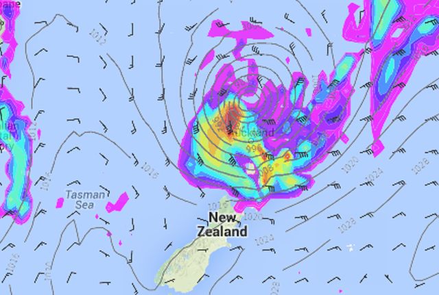
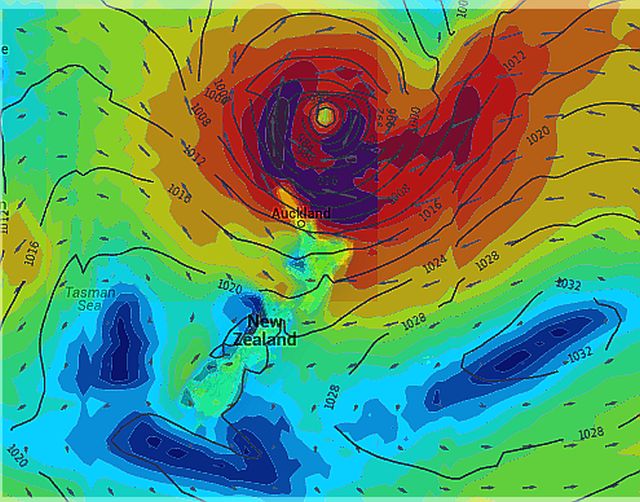
Images / Above, US & NZ data plots a deep ex-cyclone moving into the upper North Island with severe gales and heavy rain on Friday/Saturday. Below / Same data this time plotting the wind specifically.
– WeatherWatch.co.nz
Comments
Latest Video

Polar airflows set to bring cold weekend to NZ
Nor-west winds will be building over parts of NZ going into Thursday with rain on the West Coast becoming heavy…
Related Articles

Wind, rain, showers & a noticeable temperature drop for all
It will be a colder weekend right across NZ as a sub-Antarctic southerly blows through, bringing frosts, snow flurries and…
Polar airflows set to bring cold weekend to NZ
Nor-west winds will be building over parts of NZ going into Thursday with rain on the West Coast becoming heavy…

Update on incoming cold change for NZ
High pressure still covers NZ but that will slide offshore as we go into Friday and the weekend as a…


Guest on 9/05/2017 1:59am
Hi weatherwatch.
Why are we still getting TC’s this late? I have been chasing TC’s for 15 years for surf and it seems very odd to get so many so late after March. Is this global warming effects?
Cheers
WW Forecast Team on 9/05/2017 3:02am
Hi there, yes we think there’s a fairly good chance that Climate Change is playing a role in a number of weather events around the world at the moment. In particular these late cyclones are unusual and follow on from a late summer and a mild Autumn. Invercargill has a high of 18 degrees today which is very mild for Southland in mid-May. Climate change is measured over a long time so hard to know if this is definitely climate change or just a blip, but it certainly flows on from the record breaking warmth we’ve been seeing in New Zeaand these past few years (and other nations). Be interesting to see how winter unfolds in New Zealand this year.
Cheers
– WeatherWatch
Guest on 14/03/2014 5:12am
When will the Cyclone hit Palmerston North roughly?
WW Forecast Team on 14/03/2014 5:24am
This graphic shows where the storm will beat various times. See our detailed Palmy forecasts here too.
Cheers
WW
Guest on 12/03/2014 8:35am
Hey.
Im travellling from Rotorua to Aucks for Brunos sat night concert.will the roads be safe to drive on sat morning and bk sunday midday ?
WW Forecast Team on 12/03/2014 9:05am
Hi there – rain and wind will be increasing on Sat morning and decreasing Sun afternoon. Keep an eye on the forecasts and rain and wind maps above. Worst of the weather for the upper North Island, at this stage, is from Sat afternoon/evening to noon Sunday. However forecasts may change in the coming 48 hours so keep checking back.
Cheers
WW
Guest on 11/03/2014 11:55am
Is this likely to effect Dunedin??
View more comments