Tropical Storm Fehi to strike New Zealand on Thursday (+8 Maps)
29/01/2018 10:41pm

> From the WeatherWatch archives
Sunny and hot weather is dominant across many parts of New Zealand today but Tropical Cyclone Fehi will track southward directly reaching the South Island by Thursday and keeping much of its intensity.
At the same time, a cold front from the Southern Ocean will reach the southern tip of the South Island on Wednesday – the two will combine to create very heavy rain, this is great news for drought hit regions of Southland but for some it could create too much of a good thing and lead to some flooding, especially closer to Fiordland.
Persistent rain will begin around Wednesday morning on the West coast and Southland before the arrival of the front, due to building northerly wind. The eastern side of the South Island will be significantly hot until Thursday.
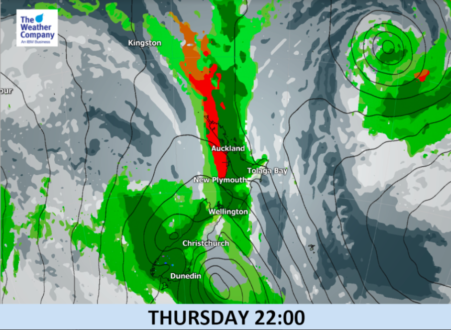
The forecast timing of the remnants of ex-cyclone Fehi (as technically it will lose it’s “Tropical Cyclone” status before it makes landfall here) to cross the South Island looks to be Thursday daytime.
Heavy rainfall is expected prior to and during landfall, especially in the southern part of the West Coast, where 12-hour rain accumulation is estimated to be around 200mm on Wednesday night and could go even higher into Thursday. Locally heavy rainfall over 30mm or even 50mm per hour is possible. Flooding and slips are quite likely.
There may also be damaging winds – although it’s harder to lock in where just yet as that involves the precise tracking of the centre of the low and the layout of mountains and ranges affecting wind flows at the time.
The cold front will remain behind the ex-tropical cyclone and will then sweep the northern part of South Island and the entire North Island from Thursday through Friday morning. A period of locally heavy rainfall and thunderstorms is likely during the passage of the front. There may be flooding in isolated parts of the North Island.
Due to the Super Moon there will be a higher than usual tide, plus storm surge, strong winds and heavy rain meaning the West Coast could have coastal flooding too.


– WeatherWatch.co.nz with The Weather Company
Latest Video

Wintry weather coming: Snow, rain, wind & sunshine
A cold front is moving into NZ from Friday to Sunday with low pressure developing west of NZ and then…
Related Articles
Wintry weather coming: Snow, rain, wind & sunshine
A cold front is moving into NZ from Friday to Sunday with low pressure developing west of NZ and then…

ClimateWatch: JULY outlook & what El Niño means for NZ
El Niño is officially here and still getting stronger in the months ahead, but it’s harder to notice its effects…

Low pressure heading to NZ this weekend & into next week
Many regions have settled weather at the moment with frosts as far north as Auckland this morning, but still some…

