Tropical Cyclone Vaianu’s track directly into NZ this weekend
7/04/2026 11:25pm
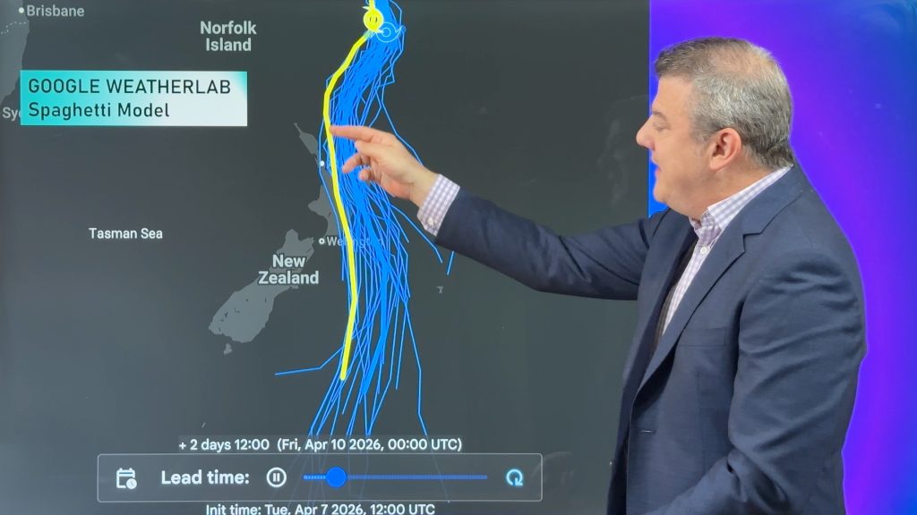
Localised heavy rain is still affecting some parts of NZ today, seperate to the tropical cyclone which is tracking directly towards New Zealand this coming weekend. Today’s downpours are now moving into Bay of Plenty and East Cape – but there are downpours/showers around other parts of NZ too. Track on rain radar now for more the latest.
Thursday and Friday see rainfall easing and drier, calmer, weather moving in thanks to high pressure, which lingers into Saturday for a number of regions too – except the upper North Island where easterly quarter winds will ramp up ahead of Cyclone Vaianu.
By Sunday and Monday the cyclone will likely track down the North Island, accelerating rapidly as it moves southwards to lie east of Dunedin by Monday, conditions easing going into Tuesday.
We have the latest tracking, rainfall and wind forecasts for the cyclone – with our next update coming on Thursday morning before noon. This weekend we will also have daily updates on Cyclone Vaianu.
Comments
Latest Video

Matariki, the long weekend + the outlook for next week
Wet weather and cloud continues along the eastern side of the country with the heaviest rain now moving into northern…
Related Articles
Matariki, the long weekend + the outlook for next week
Wet weather and cloud continues along the eastern side of the country with the heaviest rain now moving into northern…

More eastern rain, but a drier long weekend coming
Rain continues today along the eastern South Island and lower North Island, coming in from the east with heavy falls….

More heavy rain, snow – but large dry areas, especially as we go into the long weekend
Heavy rain will continue for parts of Canterbury and Marlborough over the next day or two and it will gradually…


RICHARD on 8/04/2026 10:42pm
Nice early update, I’m out today to pick up some extra supplies as it now looks like it heading my way in kawakawa bay. Thanks Phillip 👍
Dean on 8/04/2026 10:27pm
Great update.
1st time I’ve heard anyone include colour-blind people (I am.) Really appreciate the advice to go to Rural Weather.
Many thanks.
D.
Mark Broadwith on 8/04/2026 10:02pm
Fabulous detail but also summarised expertly to make the whole picture clear. Thank you!
K on 8/04/2026 8:14pm
Great report! Very informative and inclusive thank you!
B on 8/04/2026 4:05am
Hey Phil
Cracking update.
Is this TC moving so fast it will arrive before the surf it’s generating?
Cheers
B
Rachel Haumate on 8/04/2026 1:03pm
Thank you so much👍 Phil. Simple and easy to follow and understand.
Jennifer on 8/04/2026 2:47am
The most comprehensive explanation which gives preparedness a head start. Thankyou!