Tropical Cyclone Keni now Severe Category 3 storm, will merge with NZ low (+6 Maps)
10/04/2018 2:37am

> From the WeatherWatch archives
Fiji is dealing with the wind and rain from Tropical Cyclone KENI this afternoon as it is upgraded this afternoon to a “severe” Category 3 tropical storm and is now as close to Fiji’s main island as it will get.
KENI will skirt the south western coastline of Fiji across the next few hours and finally start to pull away from main centres like Nadi and Suva before sunset. Rain will continue for many areas for the rest of the day with heavy falls.
The storm is still intensifying but will weaken back to Category 2 again by/during Wednesday as it tracks further away from the equator and over cooler ocean waters. It will then track to the south west of Tonga and turn more southwards as it comes into the NZ marine area.
Around noon on Wednesday Cyclone Keni will start the process of merging with another low that is currently developing over the North Island of New Zealand today bringing stormy weather there today. As this new low over NZ tracks eastwards off the North Island on Wednesday it will start to merge with KENI’s remnants. This will form a large extra-tropical cyclone around the Chatham Islands but will move away from NZ’s two main islands as we head into Thursday and Friday.
While rough weather (gales, heavy rain) will affect the Chatham Islands from the combined storms for a time the remnants of KENI should not impact the South Island or North Island, although there is some potential it may help keep the windy, showery, southerlies lingering just a little longer in the east of the North Island, perhaps for an extra day or half day following the Antarctic southerly this week which is currently unrelated to KENI.
 – ABOVE: Air pressure map for Tuesday 6pm NZST / ECMWF
– BELOW: Air pressure map for 6am Thursday NZST / ECMWF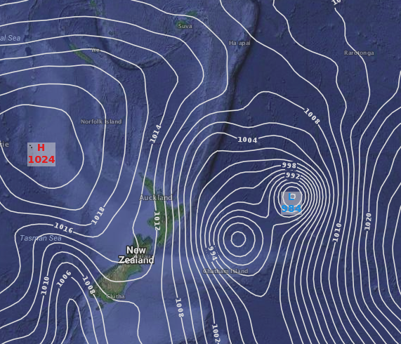

– ABOVE – TRACK MAP / FIJI MET
– ABOVE – THREAT MAP / FIJI MET
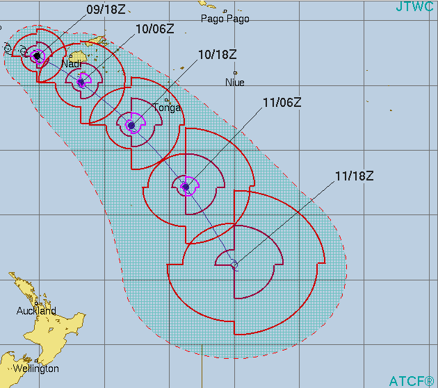 – JTWC Tracking map
 12:50pm Tuesday Fiji Rain Radar now showing the centre of KENI to the south west. KENI is tracking ESE so is currently not expected to get any closer to Suva or Nadi. Heavy rain will remain for the rest of the day though / Fiji Met / WeatherWatch.co.nz
– WeatherWatch.co.nz
Latest Video

Westerlies continue, sub-tropical for some
West to north-west winds blow through the South Island and lower North Island today bring heavy West Coast rain and…
Related Articles
Westerlies continue, sub-tropical for some
West to north-west winds blow through the South Island and lower North Island today bring heavy West Coast rain and…

Westerly change this week, unsettled but large dry areas
Westerlies kick back in again this week which will bring a break to those in the east as far as…

Matariki, the long weekend + the outlook for next week
Wet weather and cloud continues along the eastern side of the country with the heaviest rain now moving into northern…

