Thursday’s national forecast – A low with rain finally for the north of NZ (+4 Maps)
4/11/2020 3:00pm

> From the WeatherWatch archives
Slow moving rain with heavy falls is finally in the forecast for northern NZ later today as La Nina’s sub-tropical rains finally start to move in. It’s a big break to the weather pattern the North Island in particular has been affected by in recent months. Another low may also be coming in early next week.
For now, Aucklanders still must be conserving water – because there is no guarantee this will hit the Hunua Ranges (but latest rainfall estimates look even more positive with RuralWeather.co.nz estimating as much as 30 to 60mm may be coming for the storage lakes over the coming days. August was the last month to see healthy rainfall in the region – and even then it was a one off.
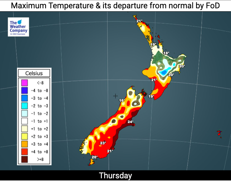
Around NZ today humid northerly quarter winds will keep temperatures above average, except for around Bay of Plenty and Waikato where the thick cloud cover will make for a fairly average day temperaturewise – after a warmer than normal start to the day.
Rain spreads down the North Island later in the day and at night.
Some rain on the West Coast also while a weak cold front brushes Southland and Otago later bringing some rain and/or showers/drizzle.
The low moving into northern NZ will also bring a burst of strong winds and gales into the Auckland region this afternoon, along with eastern Waikato and exposed coastal areas. Winds ease again tonight.
THE REGIONALS – For Thursday
Northland, Auckland, Waikato & Bay Of Plenty
Rain developing – cloudy and humid with some drizzle spells elsewhere. Heavy rain later in the day. Easterly winds developing and becoming gale in exposed areas for a time, or blustery.
Highs: 18 – 22
Western North Island (including Central North Island)
Cloudy and fairly dry – but a few showers and drizzle patches turning to rain later. Mild and humid northerly quarter winds.
Highs: 18 – 22
Eastern North Island
Quite cloudy and humid with north to north east winds. A few drizzle patches and the odd shower, long dry spells too. Rain develops at night in the north.
Highs: 20-22
Wellington
Cloudy and possibly a shower or drizzle patch otherwise dry. Humid North to North west winds.
High: 19
Marlborough & Nelson
Showers or patchy rain at times in Nelson, a few spits or drizzle patches in Marlborough otherwise fairly dry. Humid North to NW winds.
Highs: 17 – 19
Canterbury
A mix of sun and cloud, with clouds thickening at times. Sunnier spells near the coast. Warm to hot North to north west winds.
Highs: 21 – 28
West Coast
Low cloud and humid with areas of rain. A few heavy falls. Northerly quarter winds.
Highs: 17 – 19
Southland & Otago
A mix of sun and cloud, clouds thickening with drizzle/spits of rain forming around the western lakes. Warm humid northerlies bring lower clouds. Warmest in Central Otago. A cooler southerly change later in Southland and coastal Otago brings rain.
Highs: 18-25
THE MAPS:


Comments
Latest Video

Antarctic southerly for parts of NZ Fri & Sat
For the first time this year a southerly from off Antarctica is heading towards the South Island, followed by more…
Related Articles
Antarctic southerly for parts of NZ Fri & Sat
For the first time this year a southerly from off Antarctica is heading towards the South Island, followed by more…

Meteors – Your Eyewitness Reports!
WeatherWatch.co.nz receives meteor reports from all over New Zealand and the globe, 24/7/365. **CASUAL COMMENTS**If you’ve seen something in the…

Snow, rain showers & cold polar southerlies set to return
Friday will be a wintry day across NZ as the next cold front arrives, bringing snow to lower levels of…


Earl on 4/11/2020 5:46pm
Some of those graphs,don’t match the weather forecasts..Sounds like a bob eachway.
WW Forecast Team on 4/11/2020 5:57pm
For where in particular Earl? Perhaps we’ve made a mistake.
Cheers
WW