Thursday’s forecast – Low falls apart over NI as cold front approaches SI (+4 Maps)
25/11/2020 3:00pm

> From the WeatherWatch archives
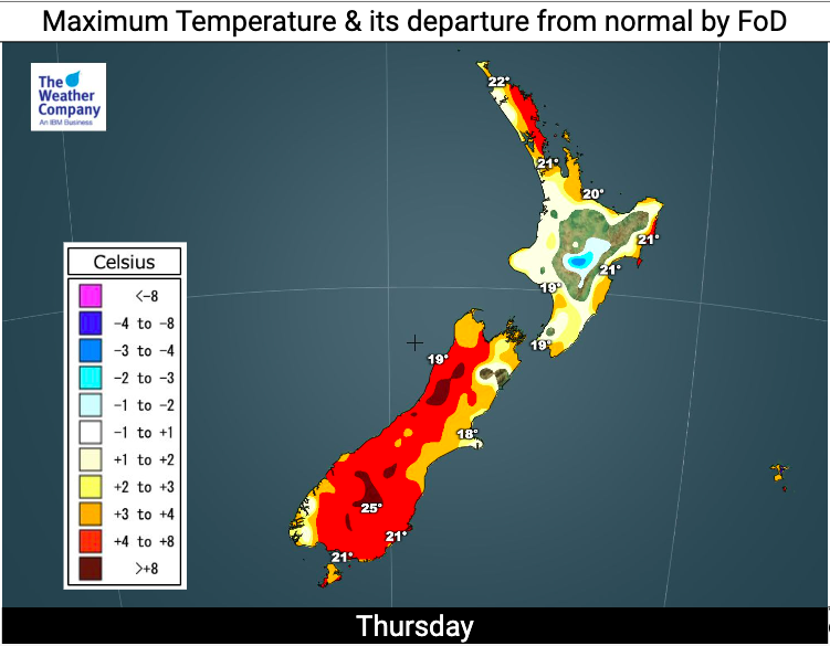
Today will be warmer for those in the east while low pressure totally unravels over the North Island.
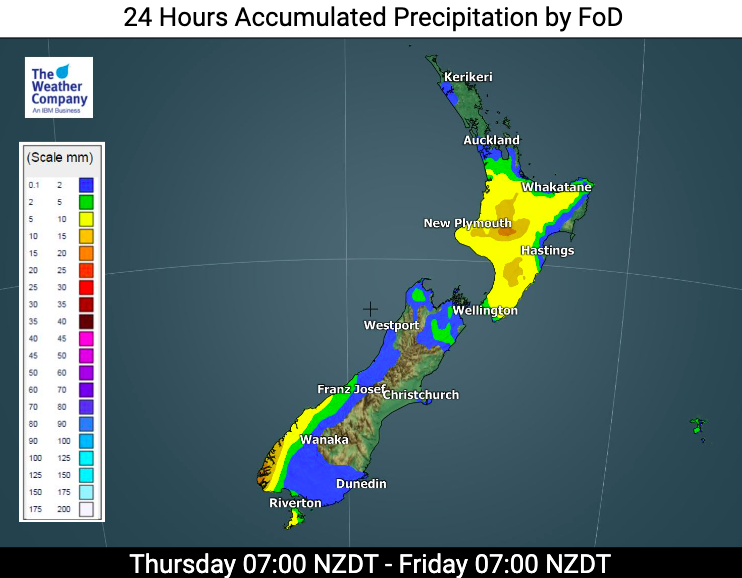
Rain clouds fall apart as remnants of the low move east over the central and southern North Island. Some downpours may be heavy in the afternoon inland before it all clears by evening.
Meanwhile much of the South Island is settled and milder but a cold front approaches the south tonight and on Friday will move up the South Island, reaching Wellington on Friday evening at this stage.
As always, refer to your local HOURLY forecasts to drill down deeper.
Here are the regional forecasts for Thursday…
Northland, Auckland, Waikato & Bay Of Plenty
Showers but plenty of long dry areas too. A chance of some isolated heavier showers inland later, otherwise showers clearing by evening. NW winds turning SW.
Highs: 18 – 24
Western North Island (including Central North Island)
Showers with a southerly quarter change kicking in. Some downpours inland may be heavy later in the day, then clearing and becoming dry for most.
Highs: 18 – 20
Eastern North Island
Mostly cloudy with showers, dry spells in the mix too. Variable winds with more of a southerly flow in Wairarapa and northerly quarter winds further north – this is due to the centre of the weakening low moving through.
Highs: 19-22
Wellington
Fairly cloudy with the risk of some early showers, then drier with sunny spells. Southerly breezes.
High: 17 – 19
Marlborough & Nelson
Mainly Sunny with an east to south east breeze.
Highs: 20 – 23
Canterbury
A mix of sun and cloud and mostly dry. East to NE winds for most.
Highs: 17-23
West Coast
Mainly Sunny with S to SW winds. Hotter inland.
Highs: 18 – 25
Southland & Otago
Becoming mostly cloudy with a few showers possible later in Southland, otherwise mainly dry. West to NW winds for most, but more N to NE in coastal Otago. Hottest and sunniest through Central Otago.
Highs: 16-26
THE MAPS:

Latest Video

Slow moving low to track over northern NZ
A low pressure zone will slowly cross the North Island over the coming days, bringing hit and miss pockets of…
Related Articles
Slow moving low to track over northern NZ
A low pressure zone will slowly cross the North Island over the coming days, bringing hit and miss pockets of…

NI low pressure, SI polar change
Low pressure will move over the upper North Island this week, bringing hit and miss pockets of heavier rain into…

Rain & showers this weekend, colder change next week
Some places will warm up over the next day or so as a nor’wester out of Australia moves across NZ,…

