Thunderstorms rumble across inland New Zealand once again – more tomorrow (+4 Lightning Maps)
28/11/2017 5:29am

> From the WeatherWatch archives
UPDATED 6:29pm — Thunderstorms are continuing to bubble up across the country.
The majority of thunderstorms are around Central Plateau and the Southern Alps, where WeatherWatch.co.nz advises motorists and locals to take extreme care in very heavy downpours which may cause surface and flash flooding, also hail.
TRACK THE THUNDERSTORMS LIVE HERE
Thunderstorms are also growing and forming along the Southern Alps.
Storms will continue to grow until in the North Island will ease this evening but in the South Island thunderstorms will continue to develop for a little longer (due to the later sunset).
Tomorrow we expect a repeat of today – although Hamilton and Auckland are more exposed to downpours.
#Thunderstorms & significant downpours continue to GROW across the southern half of the North Island and upper South Island. Most intense through the Central North Island. 2:19pm: https://t.co/pMJoYTXSlK pic.twitter.com/cp2bDR5JcH
— WeatherWatch.co.nz (@WeatherWatchNZ) November 28, 2017
IMAGES BELOW FROM 2:30PM TODAY – storms remain in similar areas as of 6:30pm. Please click the last image for the LIVE lightning tracker.

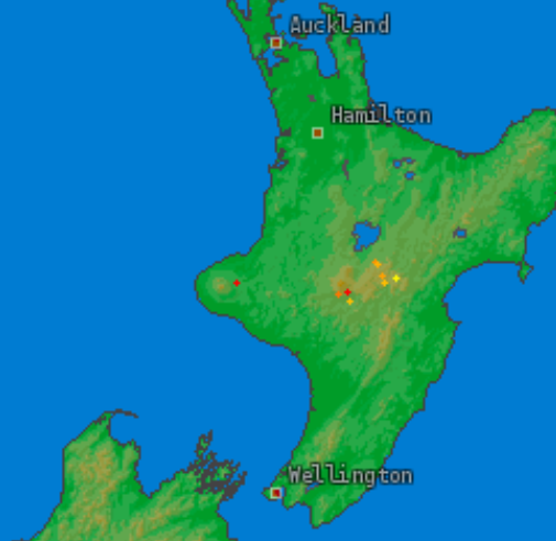
– Where the main storm cells currently lie, with active and developing thunderstorms from the Tararua’s, to Central Plateau to Taranaki.
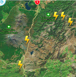
– A close up look of the Desert Road (SH1) shows thunderstorms above, some may be severe with risks of hail, surface and flash flooding.

– Unlike yesterday thunderstorms and downpours are today developing around Taranaki.

– Forecast Rain Radar for 4pm shows the areas most at risk from downpours – however coastal areas may remain completely dry in many places near these downpours.
– WeatherWatch.co.nz
Latest Video

Cold weekend, frosts return with high pressure, then a low late next week
The subantarctic airflow spreads over NZ today/tonight and into Saturday, dropping temperatures nationwide. Snow flurries are possible today to lower…
Related Articles
Cold weekend, frosts return with high pressure, then a low late next week
The subantarctic airflow spreads over NZ today/tonight and into Saturday, dropping temperatures nationwide. Snow flurries are possible today to lower…

Wintry burst of weather: Snow, squally showers then sunshine & frosts
A polar change (another one!) arrives on Friday for the South Island and goes nationwide on Saturday, leaving NZ under…

Antarctic southerly for parts of NZ Fri & Sat
For the first time this year a southerly from off Antarctica is heading towards the South Island, followed by more…

