
> From the WeatherWatch archives
From drizzly rain and showers to more intense downpours – that’s how Wednesday afternoon is shaping up over parts of the North Island as the humid easterly flow continues.
With low pressure across much of the North Island and humid nor’easters across the South Island conditions are lining up for heavy downpours to increase this afternoon and early evening – with isolated thunderstorms.
There are currently isolated heavy downpours in the same eastern parts of Coromandel Peninsula already affected by slips and flooding this week.
Waikato and Auckland are seeing heavier downpours develop while central parts of the North Island and Waikato are also seeing heavy downpours with isolated thunderstorms.
Taranaki to Manawatu, also Gisborne down to Wairarapa are also seeing areas of heavy downpours and potential for thunderstorms developing inland and spreading to the west slowly (in the easterly flow).
A few heavy downpours – and maybe an isolated thunderstorm or two – are possible in the Southern Alps/South Island ranges too.
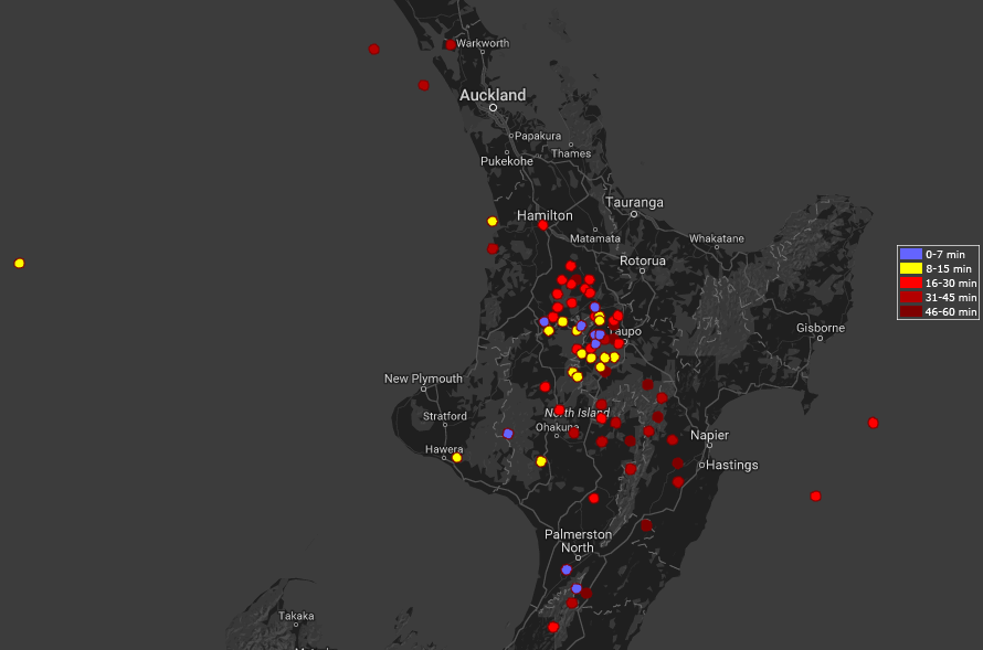
View the free lightning trackers for New Zealand here
 Above / MetService Thunderstorm Outlook
 Rain map for New Zealand this adternoon shows where the flare ups are / weathermap.co.nz
– WeatherWatch.co.nz
Latest Video

Cold weekend, frosts return with high pressure, then a low late next week
The subantarctic airflow spreads over NZ today/tonight and into Saturday, dropping temperatures nationwide. Snow flurries are possible today to lower…
Related Articles
Cold weekend, frosts return with high pressure, then a low late next week
The subantarctic airflow spreads over NZ today/tonight and into Saturday, dropping temperatures nationwide. Snow flurries are possible today to lower…

Wintry burst of weather: Snow, squally showers then sunshine & frosts
A polar change (another one!) arrives on Friday for the South Island and goes nationwide on Saturday, leaving NZ under…

Antarctic southerly for parts of NZ Fri & Sat
For the first time this year a southerly from off Antarctica is heading towards the South Island, followed by more…

