Sunday’s national forecast – Winter blast moves in, snow starts to fall to low levels (+9 Maps)
7/08/2021 4:00pm

> From the WeatherWatch archives
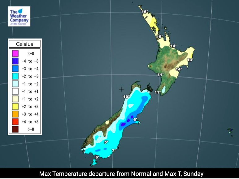
Today is a significant weather day, especially for the South Island, as a wintry change sweeps northwards bringing snow down to sea level in places and heavy snow up in the mountains.
Both main islands have snow coming in the next 24 hours with heavy falls above about 300 or 400m. But flurries are possible to sea level either today or overnight tonight and into Monday across the eastern South Island and even potentially the lower North Island on Monday.
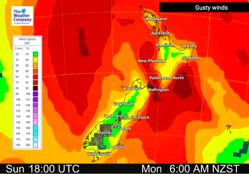
This isn’t an Antarctic blast, instead cold air from over the Southern Ocean will spread up and across the country while at the same time a small area of low pressure will form in the upper South Island/Cook Strait area. This small low will then feed more moisture into this bitterly cold southerly – and help twist the winds more southerly which makes Canterbury more exposed and makes rainfall and snowfall accumulation higher.
Milder westerlies will blow for the upper North Island but the cold front sweeps over the island during the afternoon and evening, with southerlies spreading up the island later in the day or overnight and into Monday.
Peak cold will be from Sunday PM to Monday PM across New Zealand.
We will have another update this morning with updated maps too.


WeatherWatch.co.nz is proud to be setting the international standard for weather forecasting in NZ – powered by IBM Watson, NZ’s hyper-local forecaster.
Comments
Before you add a new comment, take note this story was published on 7 Aug 2021.
Latest Video

(VIDEO) NZ 7 Day: Variety in the weather, but Southern Ocean storms waking up
Low pressure moves in to NZ from the Tasman Sea this weekend and completely falls apart – bringing downpours and…
Related Articles
(VIDEO) NZ 7 Day: Variety in the weather, but Southern Ocean storms waking up
Low pressure moves in to NZ from the Tasman Sea this weekend and completely falls apart – bringing downpours and…

VIDEO: ClimateWatch: July is the month of BIG lows, BIG highs
This month around New Zealand, Australia and the region we see big highs and big lows – bringing decent stretches…

VIDEO: Severe weather risks for NZ as low moves in
Programming Note: Apologies but we have no video on Thursday – back again on Friday! – A storm in the…


Add new comment