Sunday’s forecast: Northern winds slowly ease as patchy rain moves further inland (+9 Maps)
23/10/2021 3:00pm

> From the WeatherWatch archives
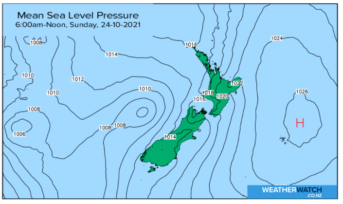
High pressure is gradually sliding off the country to the east allowing a north to north easterly flow down across NZ, boosting temperatures for some southern parts of both main islands and bringing in some rain to the north and west.
As the high slowly slides eastwards the air pressure in northern NZ will slowly drop, increasing the chances of patchy rain or showers further into the upper North Island – like into Bay of Plenty, Central Plateau and East Cape, but it will ease back in Northland and Auckland and much of Waikato.
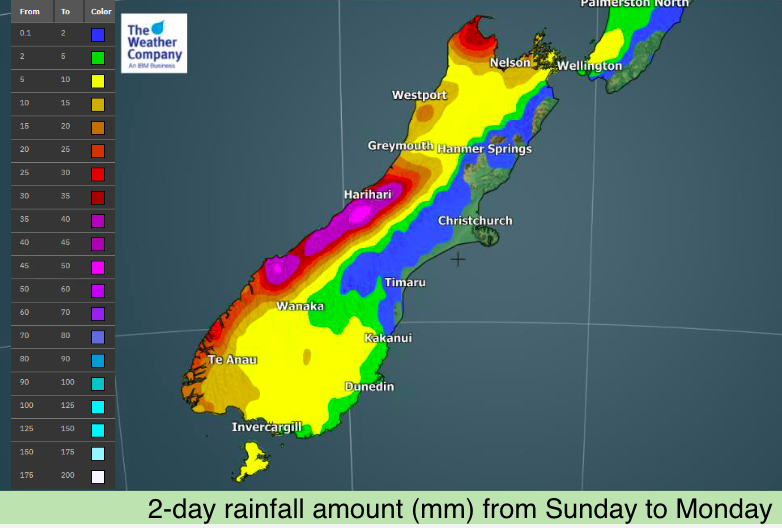
The rain is patchy and some areas have drizzle – but there will be some locally heavy falls too.
Elsewhere most places are fairly dry but cloudy – however rain moves into the West Coast as low pressure also moves closer, bringing some heavier falls. Some showers or light rain can also be expected in Southland and Otago too.
To drill down deeper please visit www.RuralWeather.co.nz – NZ’s largest weather data website, powered by IBM.


Latest Video

Wintry weather coming: Snow, rain, wind & sunshine
A cold front is moving into NZ from Friday to Sunday with low pressure developing west of NZ and then…
Related Articles

Polar airflow + northern low = pockets of heavy rain & snow
A colder change is coming – and so too is a large low which will develop and grow over northern…
Wintry weather coming: Snow, rain, wind & sunshine
A cold front is moving into NZ from Friday to Sunday with low pressure developing west of NZ and then…

ClimateWatch: JULY outlook & what El Niño means for NZ
El Niño is officially here and still getting stronger in the months ahead, but it’s harder to notice its effects…

