Sunday/Monday forecast: Dry Sunday ahead of wetter Monday, mild in northern NZ, colder change in southern NZ (+5 Maps)
2/10/2021 3:00pm

> From the WeatherWatch archives
Northerlies will spread across much of NZ today with some regions enjoying sub-tropical connections, lifting temperatures above normal. For others it will be cloudy with a cool breeze, but overnight lows will be milder as the northerly airflow moves through.
Sunday is dry (or mostly dry) nationwide, but a rain band moves across New Zealand on Monday with westerlies moving in behind that for many.
COLDER SOUTH, WARMER NORTH:
Southland and coastal Otago will have cold airflows throughout the next day or two as a wintry southerly flow moves in (localised winds may be from varying directions through, like easterlies in some areas). Dunedin might not reach the teens today and on Monday single digit maximum temperatures are expected.
At the other end of NZ it’s quite the opposite. Parts of Northland, like Whangarei, wake up to around 9 degrees this morning but overnight tonight it’s double that number at 18 degrees due to sub tropical northerlies.
To see how much rainfall you’re into see the unique rainfall graphs made specifically for your hyper-local part of New Zealand over at www.RuralWeather.co.nz.


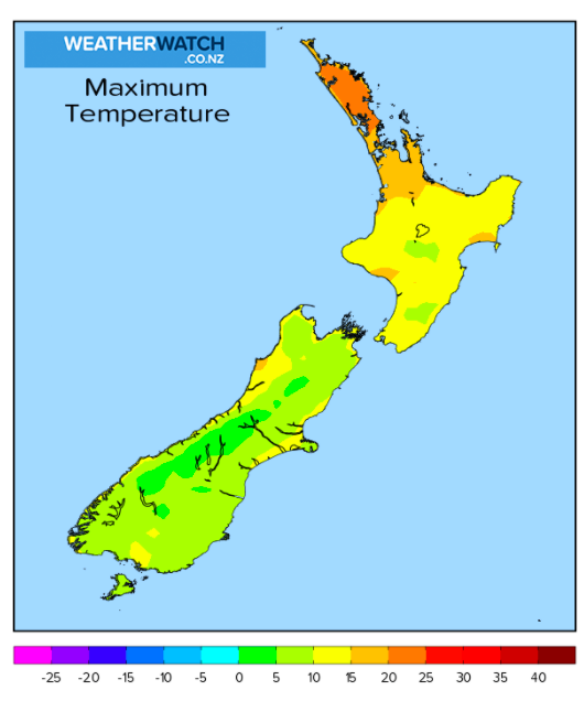
Note how much cooler the lower two thirds of NZ are

Latest Video

More eastern rain, but a drier long weekend coming
Rain continues today along the eastern South Island and lower North Island, coming in from the east with heavy falls….
Related Articles
More eastern rain, but a drier long weekend coming
Rain continues today along the eastern South Island and lower North Island, coming in from the east with heavy falls….

More heavy rain, snow – but large dry areas, especially as we go into the long weekend
Heavy rain will continue for parts of Canterbury and Marlborough over the next day or two and it will gradually…

Large low brings rain, downpours & some snow – gets colder as the week progresses
Low pressure will cross the upper North Island in the days ahead and that set-up actually pushes more heavy rain…

