Subtropical low to brush upper North Island with pockets of heavy rain (+6 Maps)
9/11/2017 2:41pm

> From the WeatherWatch archives
A deepening low in the sub-tropics is today tracking south east and will clip northern New Zealand on Saturday bringing heavy rain to some, blustery winds for others and and rough marine conditions for many. It will not impact the South Island.
Most exposed to this low will be Gisborne, East Cape and parts of Hawke’s Bay, with rainfall totals possibly over 50mm. This amount is very near rain warning criteria. The centre of the low is tracking from the north west to the south east and will track closest to the East Cape/Gisborne area.
However for other northern regions the line for heavy rain is incredibly fine – and some areas that have forecasts by other outlets for a full day of heavy rain may find a large portion of the day is dry or drizzly. In Auckland, Waikato and Northland the belt of heavy rain will mainly lie just east out at sea, but it is expected to track inland for a time on Saturday.
Totals in Auckland will be varied, with some further north perhaps having higher totals than those in the city. While a burst of rain with a chance of heavy falls is very possible in Auckland we do still expect the bulk of the heavy rain to be much further east out at sea – which means there is a chance for plenty of dry or drizzly spells in regions like Auckland, Waikato and Northland across the day too. We’ll have a clearer idea around dawn on Saturday when our detailed Auckland, Hamilton and Tauranga forecasts will be updated too.
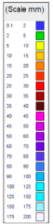
The rain map below from our new partners at The Weather Company shows the general risk. It may even be suggesting too much for some western areas – but totals for Northland, Auckland and Waikato vary from just 5mm to 25 or 30mm. Those against the Tasman Sea may get very little while those a short distance to the eastern coastline may have more. Either way, these totals are not very high.
An enormous high pressure system near Tasmania and southern Australia is also pushing into the Tasman Sea and will help to keep guiding the sub-tropical low around the eastern side of New Zealand and making its chances of a direct hit quite unlikely. In saying that, the centre of the low may still get quite close – but the high should help build pressure around the Tasman Sea coastline of New Zealand. This is why the chance for severe weather is reduced at this stage. Still one to watch for another 24 hours, so our updates early on Saturday will be key to many people.
Winds may be blustery for a time too, especially around the ranges of Gisborne, East Cape and eastern Bay of Plenty, kicking in from the SE this tends to act as a bit of a ‘reverse nor’wester’ for western areas.
While next week sees a very large high pressure system WeatherWatch.co.nz is already monitoring a potentially more problematic sub-tropical low for next weekend.
 – The situation overnight shows a large high near Tasmania, but a narrow area of low pressure forming directly north of New Zealand near New Caledonia. This map helps illustrate why we think the low will be guided to the east of the North Island.


– Maps by The Weather Company (an IBM company and an official WeatherWatch.co.nz business partner)
*Please note we are working to gradually improve the resolution in the various new maps we’re providing.
– WeatherWatch.co.nz
Latest Video

Cold weekend, frosts return with high pressure, then a low late next week
The subantarctic airflow spreads over NZ today/tonight and into Saturday, dropping temperatures nationwide. Snow flurries are possible today to lower…
Related Articles
Cold weekend, frosts return with high pressure, then a low late next week
The subantarctic airflow spreads over NZ today/tonight and into Saturday, dropping temperatures nationwide. Snow flurries are possible today to lower…

Wintry burst of weather: Snow, squally showers then sunshine & frosts
A polar change (another one!) arrives on Friday for the South Island and goes nationwide on Saturday, leaving NZ under…

Antarctic southerly for parts of NZ Fri & Sat
For the first time this year a southerly from off Antarctica is heading towards the South Island, followed by more…

