
> From the WeatherWatch archives
We’ve certainly had a thundery time across the country due to this depression that formed in the Tasman Sea then passed east over the country. Mainly at this time of year western areas can expect most of our thundery weather and that certainly did happen, however on Tuesday quite a few things came together and it made the chances of thunderstorms in Canterbury a real possibility.
The day beforehand on Monday I looked at charts and had it been summer it would’ve been a sure fire situation for thunderstorms, but due to the time of year I figured our chances weren’t looking great. As Tuesday dawned however it was nice and sunny with big cumulus clouds going up across the plains, moisture in the air was a little higher then models were predicting. This combined with a front later in the day and some ground heating provided most likely the last storm chance this season for Cantabs.
Now this is where I come into my own, I love thunderstorms and have been chasing / observing them in Canterbury since 2002. I’ve always had an interest in storms since about 1996. I got my gear together and headed out onto the plains just after 1pm, the rest of the day was quite enjoyable and presented a few challenges along the way.
Me and a friend observed a possible funnel cloud and saw a great lightning show, the clouds did look really mean. I have a website at http://www.stormchasers.co.nz with the report now up to view for this day so feel free to have a look around. I’ll be getting a video up soon.
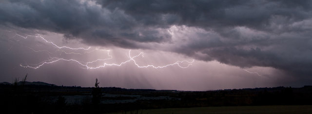
Story images / Aaron Wilkinson
– By weather analyst Aaron Wilkinson, WeatherWatch.co.nz
Latest Video

Wintry weather coming: Snow, rain, wind & sunshine
A cold front is moving into NZ from Friday to Sunday with low pressure developing west of NZ and then…
Related Articles
Wintry weather coming: Snow, rain, wind & sunshine
A cold front is moving into NZ from Friday to Sunday with low pressure developing west of NZ and then…

ClimateWatch: JULY outlook & what El Niño means for NZ
El Niño is officially here and still getting stronger in the months ahead, but it’s harder to notice its effects…

Low pressure heading to NZ this weekend & into next week
Many regions have settled weather at the moment with frosts as far north as Auckland this morning, but still some…

