
> From the WeatherWatch archives
It looks as though August 2010 will kick off off windy, wet and warm for most places as a spring-like system moves in from the Tasman Sea, predicts WeatherWatch.co.nz.
Head weather analyst Philip Duncan says the windy weather will start in the deep south on Friday morning and will drift northwards over the weekend.
“We expect very strong winds from the northerly quarter, most likely as nor’westers in the South Island and about Wairarapa and northerlies across Wellington”.
Mr Duncan says it’s possible winds will be strong enough to cause damage in some isolated areas. “Most of these areas are fairly used to gales from this wind direction so we don’t anticipate much damage but motorists and those planning on being outside this weekend should be aware that strong winds and heavy rain are on the way”.
WeatherWatch.co.nz says winter has been fairly calm for much of New Zealand so far, wind wise, and this system has more characterists of spring.
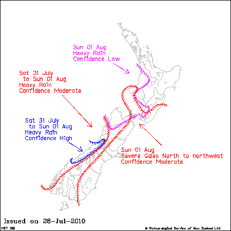
The government forecaster, MetService, is also watching the approaching system. On Thursday afternoon they predicted a “moderate risk” of severe gales about the entire eastern coastline of the South Island also Mt Taranaki, Wellington and Wairarapa.
Heavy rain is also likely across the entire western coastline and western ranges of the South Island and as far north as Waikato/Waitomo, says MetService.
Graphic / NZ Govt
Comments
Latest Video

Some polar airflows but more high pressure to affect NZ’s weather
Showers are in the forecast over the next several days, we track where and when they occur – but there…
Related Articles
Some polar airflows but more high pressure to affect NZ’s weather
Showers are in the forecast over the next several days, we track where and when they occur – but there…

Tracking the showers & colder changes
High pressure isn’t over NZ, but is nearby – and it’s affecting our airflows and who gets wet weather and…

Westerlies continue, sub-tropical for some
West to north-west winds blow through the South Island and lower North Island today bring heavy West Coast rain and…


JohnGaul on 29/07/2010 8:28am
May get NW winds strong enough to coincide with the “Big Blow” 35 years ago on August the 1st which did a lot of damage here in Canterbury.
JohnGaul
NZThS