South Island cool down – Some frost risk but a fast warm bounce back! (+6 Maps)
1/11/2020 8:23pm
> From the WeatherWatch archives
A month ago the southerly changes were much more brutal – now you can feel summer approaching.
The South Island is going through a colder change at the moment with below normal temperatures hugging Canterbury in particular today, then tonight below normal temperatures are likely in Southland with the risk of a frost.
The rest of NZ is warmer than average.
Today Christchurch and other coastal parts of Canterbury are around 2 or 3 degrees below normal for daytime highs – however, tonight it will be a few degrees warmer than average there due to cloud cover.
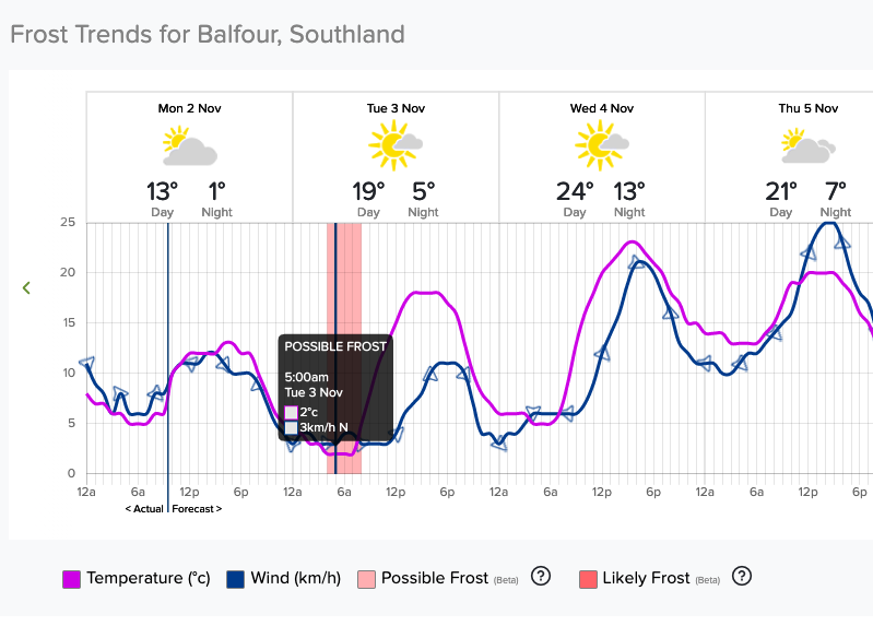
Tonight, as high pressure rolls in over Southland, overnight temperatures dip to about 0 degrees. Lumsden is down to +2, Balfour +1, Gore +2 and Invercargill +3 degrees. For some areas this will be around 3 or 4 degrees below normal.
Check out New Zealand’s only public FROST Forecaster for your specific location at www.RuralWeather.co.nz
But the warmth springs back during Tuesday daytime.
Southland’s highs will be 3 to 7 degrees above normal by Tuesday afternoon and inland areas into Otago and westwards (like Queenstown) will be over 8 degrees above normal.
Canterbury – especially coastal areas – will take another 24 hours longer to warm up with Wednesday bouncing back and highs inland reaching the late 20s with sunny skies.
Some lower North Island areas are affected by today’s southerly but warmer air and more humidity returns overnight and in the days ahead – along with cloud and drizzle.


Latest Video

More eastern rain, but a drier long weekend coming
Rain continues today along the eastern South Island and lower North Island, coming in from the east with heavy falls….
Related Articles
More eastern rain, but a drier long weekend coming
Rain continues today along the eastern South Island and lower North Island, coming in from the east with heavy falls….

More heavy rain, snow – but large dry areas, especially as we go into the long weekend
Heavy rain will continue for parts of Canterbury and Marlborough over the next day or two and it will gradually…

Large low brings rain, downpours & some snow – gets colder as the week progresses
Low pressure will cross the upper North Island in the days ahead and that set-up actually pushes more heavy rain…

