Some rain relief coming for parched rural North Island (+3 Rainfall Accumulation Maps)
27/03/2019 1:47am

> From the WeatherWatch archives
We can thank ex-Cyclone Trevor for giving a helping hand to both (or if you live on the West Coast, you may want to ‘blame’ Trevor). Today the former tropical storm lies over inland Queensland dumping incredible rainfall totals there but it’s also connected to the torrential rain and flooding moving up the West Coast of New Zealand at the moment – and this same front which will weaken as it moves into the North Island later today and overnight tonight.
But next week more of ex-Cyclone Trevor drifts into the Tasman Sea and catches a ride with another cold front in to the New Zealand area. While still not entirely locked in the chances for rain next Monday around the North Island may be the best they’ve been so far this year. Totals don’t look extreme but we do see dry areas like Waikato potentially getting a soaking. It’s a bit hit and miss and some areas may get relief while others may only get a frustrating brief helping hand. The big dry that has been developing since January 1st and the latest poll at WeatherWatch.co.nz shows over 50% say a drought is forming or formed.
WeatherWatch.co.nz has again been approached by the Minister for Primary Industries (MPI) along with other stakeholders such as Waikato Regional Council, Fonterra, Dairy NZ, Fed Farmers and more to give our thoughts on upcoming rainfall totals and chances. We now have weekly phone conferences with dozens of interested parties as we monitor the ongoing dry conditions, with some optimism April will bring relief finally – and we’ll share with you the forecasts we share with them.
We don’t want to give false hope regarding the rain potential next week – the window is fairly short around April 1 & 2 as high pressure quickly moves in by April 3 nationwide. So we’ll fine tune this again this Friday and bring you the latest expected rainfall totals around NZ up until April 3rd. It may shift from today’s maps below.
(Side note, another high comes in mid next week but behind it in the second week of April there might be another chance for rain… WeatherWatch.co.nz will keep you posted!)
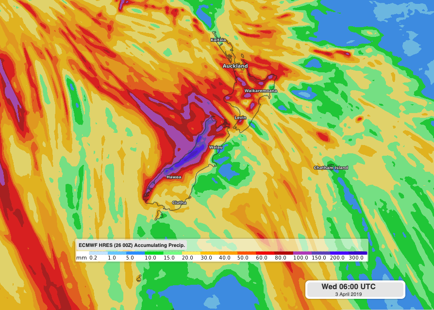
TOTAL RAIN ACCUMULATION FOR WEDNESDAY, THURSDAY AND FRIDAY
TOTAL RAIN ACCUMULATION BETWEEN NOW AND NEXT WEDNESDAY
ECMWF (Europe)
GFS (America)
– WeatherWatch.co.nz
Latest Video

Cold weekend, frosts return with high pressure, then a low late next week
The subantarctic airflow spreads over NZ today/tonight and into Saturday, dropping temperatures nationwide. Snow flurries are possible today to lower…
Related Articles
Cold weekend, frosts return with high pressure, then a low late next week
The subantarctic airflow spreads over NZ today/tonight and into Saturday, dropping temperatures nationwide. Snow flurries are possible today to lower…

Wintry burst of weather: Snow, squally showers then sunshine & frosts
A polar change (another one!) arrives on Friday for the South Island and goes nationwide on Saturday, leaving NZ under…

Antarctic southerly for parts of NZ Fri & Sat
For the first time this year a southerly from off Antarctica is heading towards the South Island, followed by more…

