Some afternoon downpours on the way as calmer, more humid, weather moves in
14/03/2019 7:55pm

> From the WeatherWatch archives
Yesterday we saw a severe thunderstorm form around Central Plateau and over the next week ahead expect to see more heavy inland downpours forming across both islands.
It’s due to a slightly more humid air flow bringing ‘thicker’ air from the sub-tropics across the country. Thicker air means it has more moisture in it – or humidity. It’s not always the same as ‘muggy’ conditions which is when we have a very hot day with extremely high humidity and it feels like the tropics, as you can have high humidity when it’s cold too, like a foggy morning in winter.
So with higher humidity levels it means more drizzly and cloudy areas in the mornings, then warm to hot days with some afternoon cloud build-ups producing inland downpours, some with thunder. Most of these downpours look inland away from main centres but may still be near populated communities.
Next week sees the highest chance for this across inland areas of both islands with perhaps the main risk in the first half of the week. Keep up to date with the tax funded Severe Thunderstorm Outlook from Government forecaster MetService too.
Despite this forecast New Zealand is still facing a mainly dry week ahead with drier than usual conditions for this time of year but these isolated downpours will also bring a little hit and miss relief to those that need it too.
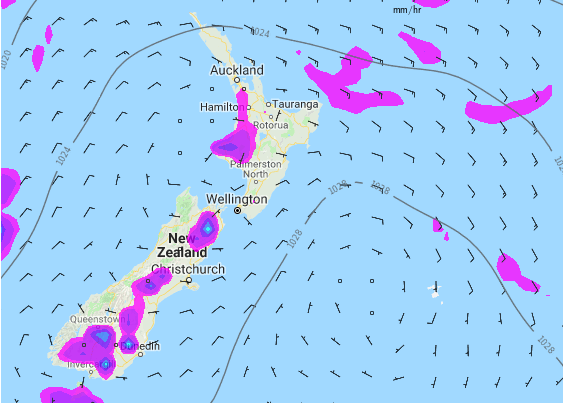 – Next Tuesday at 4pm shows afternoon downpours bubbling up. These may be preceeded by more coastal drizzly patches first thing in the morning. Daytime heating pushes that moisture inland where it converts to afternoon cloud build ups and downpours, possibly with isolated thunder. Map by Weathermap.
– WeatherWatch.co.nz
Latest Video

Cold weekend, frosts return with high pressure, then a low late next week
The subantarctic airflow spreads over NZ today/tonight and into Saturday, dropping temperatures nationwide. Snow flurries are possible today to lower…
Related Articles
Cold weekend, frosts return with high pressure, then a low late next week
The subantarctic airflow spreads over NZ today/tonight and into Saturday, dropping temperatures nationwide. Snow flurries are possible today to lower…

Wintry burst of weather: Snow, squally showers then sunshine & frosts
A polar change (another one!) arrives on Friday for the South Island and goes nationwide on Saturday, leaving NZ under…

Antarctic southerly for parts of NZ Fri & Sat
For the first time this year a southerly from off Antarctica is heading towards the South Island, followed by more…

