Significant rain event developing for the West Coast, front to weaken for North Island (+Rainfall Map)
24/03/2019 1:40am

> From the WeatherWatch archives
A band of heavy rain which has been lying over the central Tasman Sea for well over a week will finally drift on to the western South Island today and will merge with a cold front coming out of the Southern Ocean in the days ahead.
The combined rain bands will create a significant rain event with totals potentially exceeding 300 or 400mn in the next few days on the West Coast.
WeatherWatch.co.nz says while the West Coast, especially Fiordland and Westland, are used to big rainfall totals the rain coming this week is above normal and could lead to slips, flooding and road closures and detours.
The heaviest rain will from around Hokitika southwards. It’s unlikely much rain will fall over eastern areas like Canterbury, but some is possible especially closer to the ranges.
For those needing rain in the North Island this front will weaken significantly as it moves northwards around late Wednesday and Thursday, but there may be some isolated downpours which bring relief.
Those on the West Coast should keep up to date with any rain warnings from Government forecaster MetService.
FORECAST RAINFALL BETWEEN NOW AND 5AM TUESDAY (please note this map doesn’t include rainfall after 5am Tuesday and more heavy rain is expected through until late Wednesday, potentially doubling thet totals below) 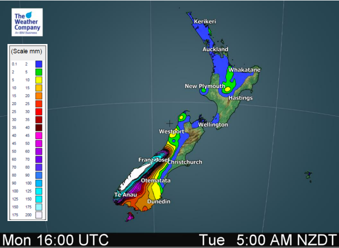
– WeatherWatch.co.nz
Latest Video

Cold weekend, frosts return with high pressure, then a low late next week
The subantarctic airflow spreads over NZ today/tonight and into Saturday, dropping temperatures nationwide. Snow flurries are possible today to lower…
Related Articles
Cold weekend, frosts return with high pressure, then a low late next week
The subantarctic airflow spreads over NZ today/tonight and into Saturday, dropping temperatures nationwide. Snow flurries are possible today to lower…

Wintry burst of weather: Snow, squally showers then sunshine & frosts
A polar change (another one!) arrives on Friday for the South Island and goes nationwide on Saturday, leaving NZ under…

Antarctic southerly for parts of NZ Fri & Sat
For the first time this year a southerly from off Antarctica is heading towards the South Island, followed by more…

