Severe Cyclone Winston remains Category 5, clearing Fiji now
20/02/2016 7:42pm

> From the WeatherWatch archives
Cyclone Winston remains a massive Category 5 tropical cyclone this morning as it continues to track west at 25km/h and clear Fiji’s main island of Viti Levu. Today or tonight it should start a SW turn too.
The air pressure is currently 925hPa with winds 215km/h, still gusting about 300km/h.
Overnight the eye of the cyclone was within 40kms of Nadi. Later today Winston should lie 300kms W of Nadi.
The destructive portion of the winds has now cleared Fiji’s main island and the worst of the rain has too, although wet and windy conditions do remain for many.
Fiji Met Service rain radar is still perfectly capturing the eye of Cyclone Winston well to the west of Viti Levu – despite the storm taking out other radar networks east of Nadi late last night.
Winston should remain a Category 5 cyclone today but is tracking out over open waters away from land.
WeatherWatch.co.nz says there remains a moderate risk New Zealand’s North Island will receive the remnants of Winston at the end of next week – however with so much uncertainty we won’t be focusing on Winston’s potential track towards the upper North Island until the end of Sunday or even on Monday.
Visit nzherald.co.nz for live updating on storm damage in Fiji now that daylight is there and reports are now coming in.
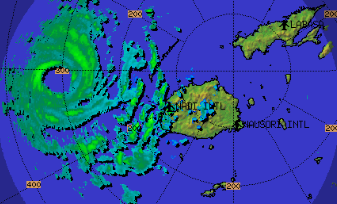 MOST RECENT RAIN RADAR FROM FIJI MET SHOWS WINSTON WELL TO THE WEST OF FIJI AND QUICKLY MOVING FURTHER AWAY TO THE WEST AT 25km/h / Fiji Met
 LATEST FORECAST TRACK / FIJI MET
– WeatherWatch.co.nz
Comments
Latest Video

Westerlies continue, sub-tropical for some
West to north-west winds blow through the South Island and lower North Island today bring heavy West Coast rain and…
Related Articles
Westerlies continue, sub-tropical for some
West to north-west winds blow through the South Island and lower North Island today bring heavy West Coast rain and…

Westerly change this week, unsettled but large dry areas
Westerlies kick back in again this week which will bring a break to those in the east as far as…

Matariki, the long weekend + the outlook for next week
Wet weather and cloud continues along the eastern side of the country with the heaviest rain now moving into northern…


Guest on 21/02/2016 2:32am
If it does and does some damage winston peters will get the blame hehe well northland wanted him to fix the roadshehe like washing them away hahaha
Richard Treadgold on 20/02/2016 11:39pm
According to the Saffir-Simpson Hurricane Scale, a Category 5 Hurricane requires sustained winds above 252 km/hr. This story, posted at 08:42 today, reports current winds (presumably sustained, since you mention gusting about 300 km/hr) of 215 km/hr. This would classify the storm in the lower end of Category 4, with winds of 209-251 km/hr.
Why do you say it “remains a massive Category 5 tropical cyclone this morning”?
Cheers,
Richard Treadgold.
WW Forecast Team on 21/02/2016 1:30am
Hi Richard, thanks for the question – quite simple – the Saffir-Simpson scale is for “Hurricanes” that form in the Atlantic and eastern Pacific in the northern hemisphere. They have different measurements and categories to Tropical Cyclones that form here. In the South Pacific this was still a Category 5 Tropical Cyclone – we don’t use the SSS to measure storms in this part of the world. But you highlight a good point. My belief is in this day of internet and satellite TV we are always hearing about Categories of tropical storms from the Northern Hemisphere, which causes confusion as they have different measurements for each Category. I personally think there should be one global standard.
Cheers
Philip Duncan
Richard Treadgold on 21/02/2016 2:57am
Thanks, Philip. I see the Australian scale is used in the South Pacific. There’s certainly a need for a global standard. You have modified my impression of this cyclone — it’s not among the largest ever globally — but I still pity the Fijians having to face that heart-breaking destruction.
WW Forecast Team on 21/02/2016 3:07am
It reached Cat 5 on the hurricane scale, but it wasn’t as powerful as some recorded Typhoons or Atlantic Hurricanes – but to be honest if you placed in a Cat 5 Hurricane or a Cat 5 Cyclone you wouldn’t notice the difference at the time on the ground amongst it. Hugely powerful storm and Winston remains Cat5 (on the Aussie scale) and Cat4 on the US Scale now.
We may try and spark some discussion about this topic in the coming weeks, as it’s a topic worthy of debating.
Cheers
Phil