Saturday’s weather headlines (x3): Cold front moves in, Some settled weather then easterlies
18/02/2022 6:00pm

> From the WeatherWatch archives
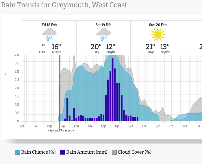
A NICE COLD FRONT TO START THE WEEKEND
The cold front to start this weekend is a welcome type of cold front, brings some rain but shouldn’t cause too many issues. Rain will be heavy in the west but it won’t be as bad as some heavy rain the West Coast has had lately. Still, streams will rise so if planning any outdoor activities please take precautions. Eastern regions get rain too in manageable quantities. To find out how much rain might be due for your location please visit ruralweather.co.nz and use the search function.

SUNDAY AND MONDAY SETTLED FOR THE SOUTH ISLAND
A ridge of high pressure lies over the South Island on Sunday and Monday bringing mainly settled conditions, on Sunday however there will be showers for Nelson / Marlborough that clear away in the afternoon.

EASTERLY QUARTER AIRFLOW WEDNESDAY THROUGH TO SATURDAY
Wednesday through to Saturday next week an easterly quarter airflow lies over New Zealand, generally this means some cloud, risk of a shower and cooler temperatures in the east. Out west expect sunnier and warmer weather.

Latest Video

More heavy rain, snow – but large dry areas, especially as we go into the long weekend
Heavy rain will continue for parts of Canterbury and Marlborough over the next day or two and it will gradually…
Related Articles
More heavy rain, snow – but large dry areas, especially as we go into the long weekend
Heavy rain will continue for parts of Canterbury and Marlborough over the next day or two and it will gradually…

Large low brings rain, downpours & some snow – gets colder as the week progresses
Low pressure will cross the upper North Island in the days ahead and that set-up actually pushes more heavy rain…

WeatherWatch App launches real-time local lightning tracker!
A bolt out of the blue! WeatherWatch has launched a live, real-time lightning tracker, enabling Kiwis to gain access to data provided by the…

